
Adapting Colorado’s Water Systems for a 21st Century Economy and Water Supply

ABOUT THE AUTHORS
Terry J. Stevinson Fellows
Jennifer Gimbel is a Senior Water Policy Scholar at the Colorado Water Center. Jennifer has experience in law and policy on national, interstate and state water issues.
Eric Kuhn is the retired General Manager of the Colorado River Water Conservation District and co-author with John Fleck of Science Be Dammed: How Ignoring Inconvenient Science Drained the Colorado River, University of Arizona Press, 2019
ABOUT THE TERRY J. STEVINSON FELLOWSHIP
The Terry J. Stevinson Fellowship is designed to spur thoughtful policy discussions and potential solutions regarding the many policy and economic challenges brought about by population growth in Colorado. The 2022 Fellowship builds on the first two years of research which covered the issues of transportation and growth in 2020 and housing and growth in 2021.
TEAMS & FELLOWS STATEMENT
CSI is committed to independent, in-depth research that examines the impacts of policies, initiatives, and proposed laws so that Coloradans are educated and informed on issues impacting their lives. CSI’s commitment to institutional independence is rooted in the individual independence of our researchers, economists, and fellows.
At the core of CSI’s mission is a belief in the power of the free enterprise system. Our work explores ideas that protect and promote jobs and the economy, and the CSI team and fellows take part in this pursuit with academic freedom. Our team’s work is driven by data-driven research and evidence. The views and opinions of the team and fellows do not reflect institutional views of CSI. CSI operates independently of any political party and does not take positions.
ABOUT COMMON SENSE INSTITUTE
Common Sense Institute is a non-partisan research organization dedicated to the protection and promotion of Colorado’s economy. CSI is at the forefront of important discussions concerning the future of free enterprise in Colorado and aims to have an impact on the issues that matter most to Coloradans.
CSI’s mission is to examine the fiscal impacts of policies, initiatives, and proposed laws so that Coloradans are educated and informed on issues impacting their lives. CSI employs rigorous research techniques and dynamic modeling to evaluate the potential impact of these measures on the Colorado economy and individual opportunity.
ACKNOWLEDGEMENTS AND STATEMENT FROM THE FELLOWS
The authors are grateful to Terry Stevinson for the opportunity and independence to address this challenging topic. The authors thank Kristin Strohm, Chris Brown, and CSI staff for assisting in the writing of this paper. We extend a special thanks to our Research Analyst intern from Colorado State University, Keian Freshwater. We sincerely appreciate the review and feedback from many individuals including our project advisory group:
Eric Wilkinson – Retired – Formerly General Manager of Northern Water
Harold Smethills – Founder of Sterling Ranch
Jill Ozarski – Environmental Program Officer at Walton Family Foundation
Jim Yahn – General Manager of North Sterling Irrigation District
Karen Kwon – Associate Project Director at Colorado River Sustainability Campaign
Mark Pifher – Retired – Formerly Executive Director of Aurora Water, 2018 Wayne N. Aspinall Recipient
Mary Gearhart – Senior Manager of Policy and Strategy at Denver Utilities
Mike King – Formerly Executive Director at Colorado Department of Natural Resources and Chief External Affairs Officer of Water Resource Strategy at Denver Water
Russ George – Retired – Former Director of Compact Negotiations of the Interbasin Compact Committee
Sonja Chavez – General Manager of Upper Gunnison River Water Conservancy District
We also want to offer a special thanks to The Walton Family Foundation for their support and partnership on this project.
When we accepted the challenge from Common Sense Institute to prepare a report on Colorado’s water future, the first questions we asked ourselves and our associates were: how can we make a difference, and how can we build on the excellent existing work of the Colorado Water Conservation Board in preparing the 2015 and 2023 state water plans? The answer that we both arrived at was that we could take advantage of our “independent” status and make observations, statements, and recommendations that need to be made but which, for various reasons, others are reluctant to put on paper or say out loud.
Thus, we acknowledge that some of the issues we’ve addressed and the recommendations we’ve made may be controversial. Many of our long-time colleagues may disagree with them. We view this as positive. A spirited and public discussion of differing views on difficult policy issues is often what is necessary for progress to be made.
While preparing this report, we’ve had to discuss sensitive issues such as interstate water compacts and decrees. The views and opinions expressed in this report are those of the authors alone and do not represent the views of the sponsors of the study, the State of Colorado, our project advisory group, or any of the agencies with which the authors are affiliated now or have been affiliated in the past.
NAVIGATING THE REPORT CONTENTS
The paper is divided into several sections. The introduction and statewide call for collaborative action give a brief overview of challenges and the competition for water. They also offer recommendations for state agency, legislative, regional and local actions. The statewide section gives a more detailed review and the increasing competition for water section analyzes economic dynamics for the future of water. Each water basin is reviewed with recommendations for action. The appendices are meant to provide even further information on different elements discussed in the main report.
Introduction
Healthy watersheds and reliable water supplies are critical to Colorado’s future. Water has always been integral to the state’s prosperity and environment and to the quality of life of its residents. Water is one of the foundations of Colorado’s unique mix of economic drivers: outdoor recreation, agriculture, high-tech industries, and thriving cities.
Recreation, agriculture, industry, and households depend on this precious and imperiled resource. Recreation alone adds $37 billion annually to the state’s economy.[i] Over 90% of Coloradans enjoy outdoor activities such as camping, hunting, hiking, fishing, rafting, climbing, and skiing, which are all heavily dependent on water.[ii] Agriculture contributes $47 billion annually to the economy, provides local food production and supports many rural communities.
Driven primarily by migration from other states, Colorado is expected to continue to grow at a significant rate particularly along the Front Range, the I-70 corridor, and in Southwestern Colorado. By 2050, Colorado’s population is expected to grow from 5.7 million to 7.5 million people. This growth will put additional pressure on limited water resources.
In fact, reliable water service to homes has already become a major expense that impacts the cost of housing. This cost is anticipated to escalate and become a driving factor in the housing market, impacting rates of home ownership, particularly in workforce housing and among first-time homebuyers. Given the recent rapid increase in the cost of home ownership, addressing the affordability and supply of water will be important for maintaining the state’s competitiveness and ability to attract and retain a skilled workforce.
Securing water resources for the growing population is not easy, and municipalities often face less resistance when choosing to buy water rights from agricultural operations. This “buy-and-dry” approach results in losses to agriculture and the communities it supports. Municipalities can also source water by transporting it from one basin to an adjacent basin, which can result in negative environmental and economic impacts upon the basin of origin.
Several populated areas of the state currently rely on non-renewable or slow-recharge groundwater supplies where aquifers are being depleted faster than they can be replenished. Municipalities in southern metropolitan Denver pump their main supplies from non-renewable aquifers and in the San Luis Valley, many agricultural wells have been shut down in order to sustain the local aquifer.
Another significant pressure on water supply is climate change and resulting aridification. Colorado’s climate is getting hotter and drier. Longer and more severe droughts interrupted by periods of wetter and more severe storms are becoming the norm. Snowpack is decreasing and runoff from snowpack is less efficient; precipitation is evaporated into the air or absorbed by the dry soil, resulting in diminished runoff into rivers. Seasonal and annual flows are more variable and uncertain. Spring runoff is occurring earlier, and in many streams there is less late-season water available for beneficial uses. Due to greater draw from available reservoir storage, less reservoir storage carries over to the next season. Moreover, with a warming climate comes a longer growing season, which means that lawns, municipal gardens, and farmers’ fields will still need water later in the season. Longer and more severe droughts have resulted in devastating wildfires which have damaged watersheds and caused significant water quality and supply problems. Stronger and more intense storms are causing severe flooding and debris flows from burn-scarred forests into rivers.
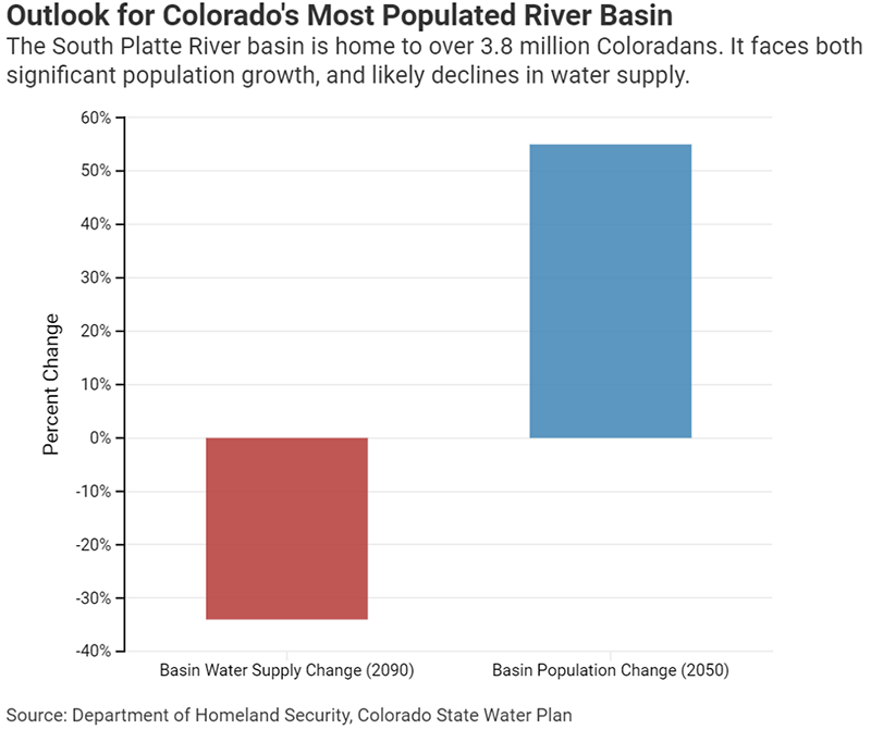
Figure 1: As water supplies decrease in Colorado’s most populous basin, projected to 2090, statewide growth is projected to significantly increase within a shorter timeframe.
As a headwaters state, all of Colorado’s major rivers flow out of the state and downstream to neighboring states (Figure 2). Under a series of interstate water compacts and U.S. Supreme Court decrees, Colorado must share water that originates in the Colorado Rockies with its neighboring states and Mexico.
The Colorado River Compact was signed 100 years ago when Colorado and other western states had much smaller and more rural populations.
This and other subsequent compacts, court decisions, guidelines, and decrees were intended to reduce the risk of interstate conflict and litigation and to provide certainty to each state about its allotment. Today however, climate change and population-driven impacts to the river flows have ushered in a new era of water supply uncertainty. Amending or renegotiating interstate compacts is nearly impossible as it would require the approval of each state’s legislature and the U.S. Congress. The water policy question facing Colorado is not how to change or modify its interstate compacts and decrees but how to best comply with them.
Unfortunately, existing decrees, some of them signed decades ago, prevent potential cooperative projects within Colorado. Rather than partnering with neighboring communities or participating in regional projects, too many growing communities have chosen to pursue their own independent water systems.
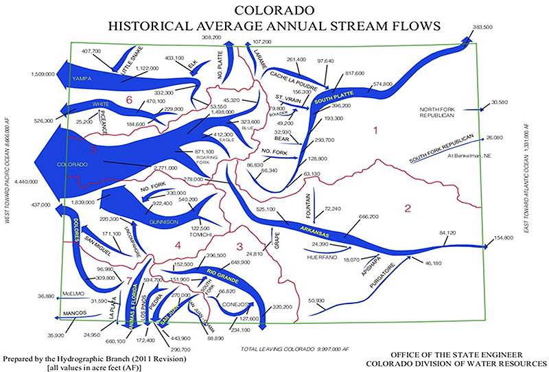
Figure 2. Significant rivers in Colorado and their directions of flow. Map source cwcb.colorado.org.
Some communities, such as the City of Aurora and Sterling Ranch in Douglas County, have implemented demand management measures such as removing non-functional turf and restricting expansive blue grass areas in new developments. Lacking statewide or regional standards, however, home developers are free to choose cities with less strict conservation standards. Regional approaches are needed.
Other communities must replace or supplement their groundwater-based systems with surface water sources because of court decisions, but available surface water sources are limited and expensive to develop.
The Colorado River, which serves over 40 million people and irrigates some five million acres of land in seven U.S. states and Mexico, is in crisis. Since 2000, the combination of reduced river flows caused by drought/aridification and the long-term overuse of available water in the Lower Basin states (Arizona, California, and Nevada) has nearly depleted Lake Mead and Lake Powell, the lower basin’s largest reservoirs, to just a quarter full. To maintain hydropower generation, Upper Basin states’ (Colorado, New Mexico, Utah, and Wyoming) reservoirs may need to be tapped as they were in early 2022.
Mountain and Front Range communities rely on Colorado River water maintained in mountain reservoirs. It is used for ski resort snowmaking and pumped overland to municipalities for household and industrial use. Ultimately, there may be reduced water availability in Colorado due to compact compliance measures (a “compact call”), limited snowpack and run-off caused by nature, a potential U.S. Supreme Court decision, or federal legislative or agency actions.
This paper provides needed background information and recommendations to meet these competing challenges facing Colorado’s water supply at both the state level and within each major river basin.
Call for Collaborative Action
Because of Colorado’s significant population growth, climate change, and obligations to other states, Colorado will have to adapt to increased competition for water. Although water laws present some structural barriers, collaborative actions can lead to needed adaptations for the 21st century. To modernize the water system, action is needed from many actors including the federal government, state and local governments, municipal water providers, along with businesses, and private citizens. A series of recommendations about what needs to be done and where actions need to occur is below:
- Colorado will have to do more with less – Incentivize regional collaboration and reduce competition for water.
Interstate compacts and court decrees, which require Colorado to share its rivers with downstream states, combined with climate change, which is reducing average flows on most of Colorado’s streams, will likely cause the state to have less water to use in the future than it has now.
State Actions
- Colorado, through agency and legislative action, should encourage more regional projects to take advantage of economies of scale and reduce water provider “balkanization.” Examples of successful regional projects are the WISE Project, a partnership of the Denver, Aurora, and South Metro Water authorities, the Windy Gap Firming Project, and the Arkansas Valley Conduit Project.
- Colorado’s detailed water plan lacks full funding. The State of Colorado and local governments must add or find financial support for regional water solutions, as the minimum costs for even moderate water projects and infrastructure development/replacement will far exceed the financial capacities of many local water providers. The State needs to take full advantage of recent federal legislation that has made available significant funding opportunities for water infrastructure.
- Modify water storage and delivery infrastructure. To address the increasing uncertainty and variability of water supplies caused by aridification, and to better manage reusable return flows and saved water, additional infrastructure, including storage and delivery systems and new storage strategies, will be essential.
Regional Actions
- In cooperation, coordination, and consultation with existing water management entities and authorities, the Arkansas and South Platte basins should consider basin-wide regional water management/policy agencies that can be created from existing entities (conservation or conservancy districts), or perhaps propose a new entity that would operate as an umbrella district(s) with the statutory authority to:
- Optimize the use of fully reusable water through the development of a reusable water “bank” and build and operate reuse and recycle projects.
- Develop and operate regional surface and aquifer storage projects.
- Build and operate regional supply and interconnect projects such as the proposed Colorado Springs “loop” and, where feasible, joint water treatment plants.
- Build interconnect projects and develop emergency backup water supplies.
- Sponsor and create incentive programs to remove and replace ornamental turf with landscapes that consume less water. Where feasible, bank or store the saved water for new uses.
Local Actions
- Where technically feasible, municipal water providers need to fully reuse and recycle water that is fully reusable under Colorado water law.
- The primary source of new municipal water should be conservation and reuse, demand management strategies such as turf removal, “firming” (making supplies more reliable), more efficient use of existing supplies, and, as a last resort, agricultural transfers, limiting “buy-and-dry” agricultural transfers to the minimum amount necessary.
- The cost of water along the Front Range is going up at an exponential rate – Increase demand management programs to reduce the need for acquiring additional water supplies.
High tap fees are threatening the ability of the state’s homebuilders to provide affordable housing and affecting what kind of businesses relocate to or start up along the Front Range.
State Actions
- The State of Colorado, by agency and legislative action, should require cities, counties, and their municipal water providers to prepare and implement detailed water demand management programs. The goal of these programs would be to incentivize turf reduction and replacement programs and to promote regional reuse and recycling projects.
- Colorado, through agency and legislative action, should implement statewide or regional turf management standards and Front Range water providers need to aggressively pursue programs to replace or remove ornamental turf.
- Colorado, through agency and legislative action, needs to consider incentivizing the sharing and transfer of reusable water, surplus supplies, and backup supplies among neighboring cities, regions, and between agricultural owners of water.
- The Colorado legislature, state agencies, and municipalities should create a “state” economic assistance program for those who are increasingly becoming unable to pay the high utility bills associated with bringing a scarce supply to market (in a time of increasing income inequality).
- A large portion of our state’s share of Colorado River supplies, including those used for transbasin diversions, is at risk – The state must act to secure existing supplies and be prepared to use less from the river in the future.
Flows have diminished and mainstream reservoirs controlling the management of interstate rivers are at dangerously low levels. A large portion of Colorado’s current uses of Colorado River water could be subject to curtailment or reduction in supplies. These post-compact uses include almost all exports to the South Platte and Arkansas River basins and to important Western Slope municipal, snowmaking, and industrial projects.
State Actions
- Colorado, under the leadership of the Colorado Water Conservation Board (CWCB), should pursue both intra- and interstate strategies to minimize or eliminate the threat that existing projects will not be able to divert water due to Colorado River Compact compliance.
- While recognizing that there are tribal rights to develop more water, Colorado needs to be fully prepared to use less Colorado River water in the future.
- Colorado and its two Western Slope conservation districts should implement a program to retire marginally productive irrigated lands that consume water but produce little or no economic return.
- Preserving agricultural water supplies is becoming more challenging and yet more critical to the state’s diversified economy – Action is needed to prioritize long-term water supplies for agriculture.
State projections anticipate an acceleration of the transfer of water rights from agriculture to municipal use. Preservation of Colorado’s agricultural industry and the rural communities its supports are both economic and cultural priorities. Statewide, agricultural uses make up over 90% of the state’s total consumptive use of water, but much of the agricultural use is far away from the Front Range area where the growth is occurring. This puts a target on very productive South Platte agriculture near the Front Range. For too many growing communities, agricultural conversions (“buy-and-dry”) are the only viable water sources. This is creating a rush to acquire farm and ranch properties for their agricultural water rights.
State Actions
- The CWCB, in coordination with major agricultural water suppliers, should implement programs to supplement and stretch the water available for irrigation purposes, including storage. The implementation of agricultural water use efficiency programs needs to be evaluated at the regional level. In some cases, it may cause more problems than it solves.
Regional Actions
- Colorado should encourage more regional solutions that are set up to meet municipal uses while preserving agricultural supplies, such as the Arkansas Valley “Super Ditch,” a regional project among ditch companies as an alternative to “buy-and-dry” approaches. The Platte Valley Water Partnership is another potential example in the early stages of development.
Local Actions
- Municipalities should provide financial assistance to farmers to invest in water saving technologies, thereby reducing water demands without impairing economic return.
- Climate change is impacting more than just the supply of water – Action is needed to increase resiliency of critical watersheds, aquatic habitats, and the recreation industry.
State Actions
- Maintaining the health of Colorado’s forests will be critical to preserving and protecting existing water supplies. Restoring and maintaining forests impacted by beetle kill and devastating fires will require significantly more resources.
- Many of the state’s most heavily used streams for recreation, and environmental habitats rely on releases from upstream reservoirs to maintain both flow levels and water temperatures during the late summer. Examples of these areas are the Upper Arkansas River, the Colorado River from State Bridge to Glenwood Springs, and the South Platte River through Cheeseman Canyon. As climate change alters the hydrograph, maintaining flow levels for fishing and recreation will be more difficult and more storage will be needed.
- Colorado’s rivers are part of a much larger interconnected system – Colorado must be a leader in the development of innovative cooperative projects both within Colorado and with its neighboring states.
State Actions
- Colorado must fully fund the State Water Plan! The 2015 State Water Plan and its successor, the 2023 Draft Plan, are excellent roadmaps. They identify much of what needs to be accomplished to meet the state’s future water needs, but without better and more secure funding from a variety of sources, including public-private partnerships, the quality of life that has made Colorado such a wonderful place to live will be diminished.
- Many potential cooperative projects within Colorado are blocked or made very difficult by water right decrees and agreements signed decades ago (often with the federal government). Keeping the underlying framework of the prior appropriation doctrine, Colorado should be open to—and state agencies should be the catalysts for—modifying or amending these limitations. Examples of this are the agreements that prevent water stored in Lake Nighthorse to be used for irrigation purposes and the decrees and stipulations that prevent fully reusable return flows to be used outside the boundaries of the entities that appropriate the water.
- Most, if not all, of Colorado’s neighboring states are facing the same basic water supply problem: growing demand for a diminishing resource. This should open the door for innovative projects between states and water agencies within the states. The success of projects that benefit water use in all three Lower Colorado River Basin states, such as Metropolitan Water District’s water recycling project (California) should be considered a template.
- The State, through legislative and agency action, should financially support studies about water conservation and reuse projects, both agricultural and municipal, as well as the application of climate science to future water use decisions.
- Colorado needs to invest more in its human resources that represent the state on intra- and interstate water matters, that administer water rights, and that conduct water-related research.
Statewide Issues and Drivers
Geography and Hydrology
Figure 3. Basin roundtables in Colorado. Map courtesy of cwcb.colorado.org
Colorado is a state of many landscapes from plains and prairies to high mountain peaks. The snowpack in the mountains is the largest reservoir of water in the state. The Rocky Mountains divide the state into three main areas: the Western Slope, the Eastern Slope, and the San Luis Valley. Average precipitation varies from over 70 inches in the mountains to less than 7 inches in the valleys and plains.[iii] Water supply has always been variable but drought and aridification are producing more dramatic swings.
Colorado is a headwaters state of several interstate rivers; more than 60% of its water supply flows out of the state to meet obligations under compacts and U.S. Supreme Court decrees and supply 18 U.S. states and Mexico.[iv] The flow “snake” diagram above in Figure 2 shows the average amount of water in each of the river basins and how much leaves the state and the relative size of Colorado’s rivers.
70% of surface water supplies originate west of the Continental Divide, but nearly 90% of the population lives on the eastern side.[v] Consequently, many Eastern Slope projects bring Colorado River water over or through the mountains—these are referred to as transbasin diversions. Approximately 10% of Colorado’s water supply is for municipal and industrial uses and 90% is for agricultural uses.[vi]
Nearly one-fifth of Colorado’s water supply comes from groundwater.[vii] Non-alluvial aquifers are not hydrologically connected to a river system and therefore have a slow recharge rate. Over-pumping can cause a significant lowering of the water table. The San Luis Valley has experienced the devastation from over-pumping an aquifer, which has led to economic losses.
Population, Demographics, and Water Use
When the Colorado Territory became a state in 1876, the population was about 80,000. By the early 1920s, when the Colorado Legislature approved the Colorado River and South Platte River compacts, the state’s population had grown to 940,000. Denver and Pueblo were the largest cities at 256,000 and 43,000 respectively. About 52% of Coloradoans were rural residents of farms, ranches, or towns with less than 2,500 people. Colorado’s population was relatively stable until after World War II, when growth, especially on the Front Range, accelerated. In the early 1980s, Colorado’s population reached three million. The 2020 Census reported a population of 5.77 million people (the state’s population is estimated to be about 5.9 million in 2022). Denver (739,000 people), Colorado Springs (491,000), and Aurora (398,000) are the largest cities. Approximately five million people, or 87%, live on the Front Range, about 90% live on the Eastern Slope, and 10% live on the Western Slope.
The Colorado State Demographer’s office makes detailed projections of future population growth. The November 2020 projection is that Colorado will have a population of 6.5 million by 2030 and 7.5 million by 2050.
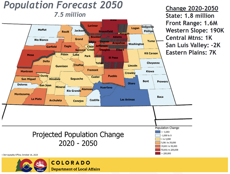
Figure 4. Colorado 2050 population forecast by county. Map courtesy of Colorado Department of Local Affairs.
In recent years, statewide growth projections have been going down. When the 2015 Colorado Water Plan was published, the population projection for 2050 was over 9 million. In just five years since then, that projection has fallen by 20%. To water use projections, both the demographics and localization of the growth matter. Population projections show that Colorado’s population is aging and becoming more concentrated. As a population ages, it generally becomes less mobile and more likely to be comprised of homeowners rather than renters. In terms of localization, the projections predict that 90% of the growth will occur along the Front Range and that the remainder will occur in a handful of counties on the Western Slope.
Because of water supply balkanization, there has historically been a disconnect between the Colorado Demographer’s population projections for the Front Range and the sum of the population projections used by the many individual water providers. Most, if not all, water utilities plan their systems based on the concept of the “build-outs” of their current service areas plus lands that might be annexed into their service areas in the future. The goal is to have a water “portfolio” large enough to meet all foreseeable future needs. The problem is that the total population for the build-outs of all these communities far exceeds the true population of the Front Range as a whole.
There are historically valid reasons for this build-out approach. Lacking regional water providers, many communities had no choice but to develop independent systems. Land and water supply planners don’t know where actual growth will occur and often use water supply availability to compete for growth with neighboring communities. Left unchecked, however, this approach will accelerate the shift to “buy-and-dry” sourcing and increase costs for all Front Range water providers. It is one of the many reasons that more regional solutions are necessary.
Climate Change
In 2008, the Colorado Water Conservation Board published “Climate Change in Colorado: A Synthesis to Support Water Resources Management and Adaptation.” The report concluded that climate change was affecting Colorado’s use and distribution of water and suggested that, by the middle of the 21st century, Colorado would see a decline in the runoff of most of its rivers and an overall reduction in the water supply available to the state. In the years since that report was published, its conclusions have been verified and the anticipated impacts have worsened. Colorado is getting hotter and drier; this is reducing the surface water available for use and increasing the demand for this diminishing supply.
The graph below shows the range of annual temperatures since 1895. The trend is clear. Colorado’s average yearly temperature has increased by 2 degrees F in the last 30 years and is projected to warm by an additional 2.5 to 5 degrees F by 2050.[viii]
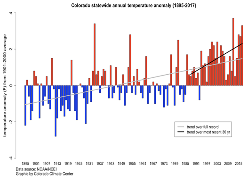
Figure 5. Colorado statewide annual temperature anomalies (1986-2017). Graphic courtesy of Colorado State Forest Service.[ix]
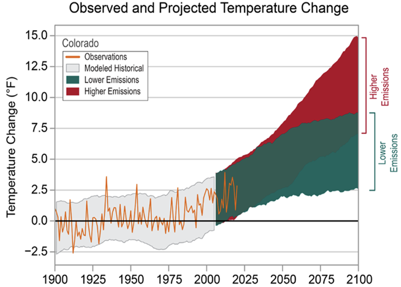
Figure 6. Observed and projected temperature changes, in degrees F. Graphic courtesy of NOAA State Climate Summaries 2022.[x]
The impacts of climate change have been more obvious on the state’s southern and western streams, especially the Colorado River and Rio Grande systems. Since 2000, the estimated average annual natural flow at Lee Ferry, the compact point that divides the two basins, has declined from a 20th-century average of 15.0 million acre-feet per year to 12.2 million acre-feet per year—nearly 20%.[xi] There is no similar natural flow database on the Rio Grande but based on the long-term gauge record at Del Norte, that river is experiencing similar declines.
Climate scientists conclude that what we are now experiencing should no longer be referred to as a “drought.” Instead, we must recognize and adapt to an accelerating and permanent trend of watershed “aridification.”[xii] The term “aridification” describes the overall impacts of increasing temperatures on river systems where a combination of drier soils, warmer springs and falls, and a “thirsty” atmosphere means that, at the same levels of precipitation, stream flows will be less. As an example, in 2020, the Upper Colorado River Basin had an 80% snowpack that only produced a 35% runoff. Similar conditions were observed in 2021 and 2022.
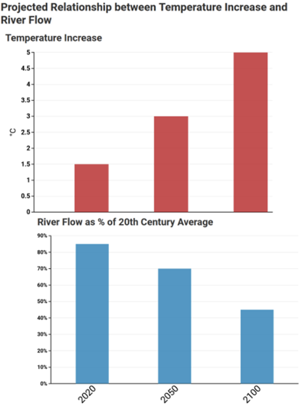
Figure 7. Projected relationship between temperature increases and river flows. Data sourced from 2023 Draft State Water Plan p. 3-13
Aridification is impacting forest and watershed health. In 2020, Colorado experienced record wildfires which were followed in the summer of 2021 by strong storms that caused large debris flows. The combination of drought, wildfire, and flooding has had significant impacts on stream habitat, water quality, and the ability of existing systems to divert and treat water. Twenty years after the Hayman Fire in the South Platte River basin southwest of Denver, the fire’s impacts on Denver Water’s collection system are still being mitigated.[xiii] Likewise, restoration of the impacts from the large Troublesome and Cameron Peak fires from 2020 will take years.
Rising temperatures impact water demand as well as supply. Increasing temperatures means a longer growing season and higher plant transpiration rates, so that existing crops and turf, especially grasses, will consume (transpire) more water. If the water is available, this additional consumptive use could be significant. In 2015, the Front Range Water Council (a consortium of transbasin diverters) estimated that rising temperatures on the Front Range could increase the total consumptive use on existing lawns and parks by 40,000 acre-feet per year. Put in perspective, in today’s environment, projects to develop 40,000 acre-feet would cost well over two billion dollars and would provide a new water supply for approximately 250,000 new homes.
There are still many uncertainties and unanswered questions about the long-term impacts of climate change on Colorado’s water supply. A warmer atmosphere holds more water vapor, which means that it produces storms that are wetter and stronger. The impacts of climate change on the flows of the North and South Platte Rivers are not as obvious and require more study. Despite the impacts of climate change, compared to other regions of the country, Colorado will still be a nice place to live, work, and raise a family. Thus, it’s possible that Colorado may become a haven for domestic migration as Americans seek refuge from areas of the country more impacted by climate change.[xiv]
Adapting to the hydrologic impacts of climate change will require a broad range of measures: programs to limit and replace turf (lawns), retiring marginal irrigated lands that will consume more and more water as the temperature rises, investing a lot more money in watershed health and wildfire prevention and restoration programs, and modifying water diversion and storage systems to accommodate both higher and lower stream flows. Adapting Colorado’s water systems to climate change will require significant public investments in infrastructure to implement the necessary conservation and reuse programs and to manage, store, and move water to where it is consumed. More state funding, as identified by the 2015 Colorado Water Plan, must be made available for these projects.[xv]
Reusable Water Supplies
Pursuant to Colorado water law, the use of native (in-basin) surface water is normally restricted to first use only; the return flows belong to downstream appropriators. In-house uses are 90–95% non-consumptive, so almost all in-house (and in-building) water uses are returned to rivers via sewage treatment plants. Return flows from the irrigation of lawns, parks, golf courses, and croplands vary depending on the method of irrigation, but as a general rule-of-thumb, these return flows are about 50% of immediate prior use. Many industrial uses, such as thermal plant cooling towers, are 100% consumptive. For change-of-use cases, preserving the historic pattern of return flows is a critically important issue.
There are, however, important exceptions to the first-use limitation. The return flows from water imported through transbasin diversions, pumped from non-tributary groundwater wells, and the consumptive use portion of irrigation water that has been changed to a different use are all fully reusable. The management and full use of reusable return flows will be a critically important source of future water, especially in the Arkansas and South Platte Basins that are heavily reliant on imported water from transbasin diversions out of the Colorado River. The major exception to the reuse of imported water is the C-BT Project whereby return flows have been dedicated to the South Platte River.
The return flows from reusable water are used as sources of exchange water and as sources of water for reuse projects. For example, both Colorado Springs and Denver use portions of their transbasin return flows to meet downstream senior calls, taking like amounts of native water at their upstream diversion points. Return flows are the major source for Aurora’s Prairie Waters Project. Reusable water gives these cities a multiplier effect from their fully reusable water: one acre-foot of diverted water can be turned into one to two acre-feet of water supply. There are, however, practical limitations. In many cases, the exchange capacity of the native stream (South Platte or Arkansas) is limited, or the return flow accrues to the river at a time when there is no downstream need for the water.
Fully using all reusable return flows on the South Platte and Arkansas Rivers will require a coordinated regional river-wide approach. It will also require additional infrastructure including storage, the implementation of reusable water banks, and, in some cases, relaxing decree limitations that prohibit or limit the use of return flows. The infrastructure costs to fully use Colorado’s reusable water will be significant. More state funding is essential!
Agriculture
There are over 3 million acres of irrigated land in Colorado that contribute $41 billion to the state’s economy.[xvi] Since agriculture uses most of available water supplies, it seems to be an easy target for conserving water to add to river supplies. However, there are several factors that need to be noted. First, as the climate gets hotter and the growing season longer, plants will be using even more of the available water supply. Second, depending on the location and basin or subbasin in which the agricultural use is located, more efficient uses of water on the ground may result in less water in the river. For example, as discussed below, in the South Platte River, runoff from fields in the upper part of the basin supplies farmers and ranchers in the lower basin. Each molecule of water is used and reused several times. With more efficient practices, smaller return flows occur and can change the regimen of the river. Water for irrigated land, that is not used by plants or does not evaporate, returns to the river to supply users downstream.[xvii] The same is not necessarily true in urban areas, where irrigated acres are being lost to growing cities.
The acquisition of agricultural supplies by Front Range cities has been occurring for decades but has accelerated in recent years. In general, the conversion of agricultural water into municipal water happens in three ways. The first is by land annexation, whereby adjacent agricultural land becomes part of a city and yields its water rights to that city. The second and more controversial approach is that whereby a city acquires agricultural water rights or shares in agricultural systems apart from the city and transfers the rights or system shares to municipal use. In these cases, the physical water is either moved to the city’s diversion by exchange, or piped back to the city. This type of transfer is more controversial because it dries up the previous agricultural lands (hence the term “buy and dry”). The third approach, which is limited and primarily occurs at headwaters, involves a city which buys a downstream senior agricultural water right and retires it to improve the yield of its upstream junior water right. There is no formal water rights transfer; the acquiring city simply stops irrigating the lands it now owns.
The purchase of agricultural water rights, the “buy-and-dry” approach, has been a controversial water topic for generations. For example, the Windy Gap Project was conceived by six northern Front Range cities in the 1960s, all in the service area of the Northern Colorado Water Conservancy District. Their goal was to develop a water supply that would take the pressure off the purchase of Colorado-Big Thompson Project (C-BT) agricultural shares by the region’s municipalities. Share ownership of the C-BT, as planned in 1938, was 85% agriculture and 15% municipal. By the mid-60s when Windy Gap was designed, it was still 70% agricultural and 30% municipal. Today, it’s over 70% municipal in share ownership, although in most years, agricultural uses still consume over 50% of the project water deliveries. Likewise, the Twin Lakes Project in the Arkansas Basin was all agricultural in 1936 and today is 95% municipal owned.
Drying of agricultural lands can have a devastating effect on rural communities, as evidenced by what happened in Crowley County. Years ago, Pueblo, Colorado Springs, Pueblo West, and Aurora bought water rights to most of the irrigated land in the county. The county lost its economic base. Generally, the farther away the acquisition is from the purchasing city, the more controversial. These “distant” acquisitions often have significant impacts on the local communities where the farms are dried up. The bottom line is that water rights are property rights that can be bought and sold. For municipalities, there are often no realistic alternatives.
Environmental Programs
Colorado has had a long history of successful popular environmental programs. It was the first western state to incorporate minimum stream flows into the prior appropriation system. Today, its instream flow program, administered by the CWCB and approaching its 50th anniversary, protects thousands of miles of streams. Colorado is a party to three multi-state endangered species recovery programs—one on the South Platte River and two on the Colorado River system. The broad goal of each of these programs is to protect endangered species while allowing water use and water development to continue. Despite significant headwinds, these programs have been successful. They have made progress on species recovery and importantly, the operation of the programs has meant that the divisive, expensive, and endless litigation that has plagued other river systems with endangered species problems like the Klamath and Sacramento Rivers have been avoided.
The 2015 Water Plan and the individual basin plans prepared by the roundtables have brought new energy and financial resources for the restoration and improvement of stream flows and the aquatic environment. According to the 2023 Draft Water Plan, 25 stream management plans have been completed. The individual roundtables have already funded many projects designed to restore wetlands and stream habitat and modify existing diversion structures to make them more “fish-friendly”. Many more similar projects are listed as priority projects in the basin plans. Some of these are relatively small and easy to accomplish and others are more complicated, requiring cooperation and funding contributions from many parties that have traditionally been considered adversaries. An example of the latter is the Windy Gap Bypass Project, a $33 million project that will reconnect the Colorado River around the Windy Gap Diversion dam.[xviii]
Indeed, Colorado has a long and accomplished record of successful environmental innovation and stewardship. Looking forward, however, many difficult challenges remain. The combination of statewide growth, climate change, and intense competition for every drop of available water will stress the state’s stream flows, watersheds, aquatic environments, and water-based recreation industry. For example, the stream flow conditions on the Upper Arkansas River that support over a hundred miles of gold-medal fishing waters and the nation’s largest commercial river rafting industry are highly dependent on upstream reservoir operations and the delivery of transbasin imported water to downstream users. Will this imported water still be available in the future? Will the reservoir capacities be sufficient to meet both the needs of the end-users, the fish, and the recreation industry? Meeting these challenges will require continued diligence, new cooperative efforts, increased funding, and flexibility and leadership by the state agencies, water providers, local communities, and the recreation industry.
The Colorado Water Plan and Basin Implementation Plans
The Colorado Water for the 21st Century Act of 2005 created basin roundtables to facilitate discussions on water management issues and encourage locally driven solutions. There are nine basin roundtables — one for each water basin and one for the metro Denver area. The Act also created the Inter-basin Compact Committee, a group of water interests around the state, including appointments from each roundtable, a member from each house of the General Assembly, and six members, appointed by the Governor, with expertise in environmental, recreational, local governmental, industrial, and agricultural matters. The IBCC and the roundtables assisted the state at creating the first comprehensive water plan in 2015. The Colorado Water Plan analyzed existing supplies and projects and projected needs out to 2050. The Water Plan included reports of each water basin and the Metro basin, as well as recommended implementation plans of projects to develop or manage supplies and to protect recreational and environmental interests.[xix] In 2019, the Colorado Water Conservation Board released a technical update to the Water Plan.[xx] Each basin roundtable released its Basin Implementation Plan early in 2022.[xxi]
In the summer of 2022, the Colorado Water Conservation Board released a draft of the next iteration of the plan. On a statewide basis, the Plan predicts that gaps in water supply for 2050 will be from 230,000 (average hydrology and weak economy) acre-feet to 740,000 acre-feet (hot climate, reduced supplies, population growth). The Colorado Water Plan is a complete and comprehensive study with recommendations for actions to achieve a sustainable water future. Unfortunately, the Water Plan is not fully funded.
The 2019 technical update to the Colorado Water Plan projects the economic effect of not meeting Colorado’s future needs.
Table 1. Statewide reduced economic impacts by 2050 of not meeting Colorado’s water needs. Data sourced from the 2019 technical update to the Colorado Water Plan.
| Reduced Economic Output | $53 billion to $90 billion |
| Reduced Gross Regional Product | $30 billion to $51 billion |
| Reduced Employment | 355,000 to 587,000 jobs |
| Reduced Labor Compensation | $20 billion to $33 billion |
| Reduced State and Local Tax Revenues | $3.4 billion to $6.0 billion |
| Reduced Consumer Welfare | $1.2 billion to $2.1 billion |
Individual basin economic impact charts from the technical update can be found in Appendix K.
Thinking Outside the Box
Through decades of fighting over contentious water projects in water courts and in front of local, state, and federal permitting agencies, many of Colorado’s existing water supply projects are limited by decrees, contracts, permit conditions, and, in some cases, federal laws. These limitations were imposed for many legitimate reasons such as protecting existing water rights, preserving return flow patterns, preventing speculation, protecting stream flows and wetlands, limiting impacts upon basins of origin, and protecting water quality. Today, however, many of these limitations are unnecessarily restricting our ability to fully use existing water supplies and creating obstacles to the development of new innovative and cooperative projects.
It’s past time to reevaluate many existing restrictions and limitations so Colorado can make more efficient use of existing infrastructure and explore new “out-of-the-box” projects. We’ve listed a few examples of such projects recognizing the complexities and controversies associated with each and that there are many more (and possibly better) examples.
- Is it time to consider the next generation of a WISE Project? A next-generation Wise Project will almost certainly require Denver and possibly Aurora to provide additional high quality surface water (available in most years). In return, Denver and Aurora would gain access to critical drought-year water. The advent of new programs to limit and remove ornamental turf in Denver and Aurora may open new opportunities to deliver saved water. The Western Slope will need to be willing to allow Denver to deliver more of its water outside its service area. There are many potential benefits to the Western Slope of doing so. Reducing Denver’s drought-year reliance on Colorado River water, providing an additional revenue stream, and providing a source of water for headwaters development and stream flows are just a few.
- Is it time to consider a Colorado Springs/El Paso County version of the WISE project? In return for a drought year supply of groundwater from its neighbors, Colorado Springs would deliver those entities surface water supplies that are surplus in most years, perhaps via a “loop” project. Again, it might require the Western Slope and other parties to agree to relaxing service area limitations in return for something of value.
- Should the State of Colorado consider incentivizing additional participants in the Platte Valley Water Partnership Project? This project is now in the early stage of development.
- Despite years of drought in southwestern Colorado, the Western Slope’s newest reservoir, Lake Nighthorse, which has a capacity of 120,000 acre-feet, has been unused, in part because the use of the reservoir’s waters for irrigation and other purposes is restricted by law. Is it now time to consider how to relax those limitations to make better use of a valuable source of reservoir water? Unwinding the complex set of project agreements will not be easy, but the alternative may be worse. Southwestern Colorado will continue to be impacted by aridification while a large source of stored water goes unused.
- At the interstate level, there may also be opportunities. On the South Platte River, could there be cooperative projects that might benefit both Colorado and Nebraska along the South Platte River? Should Texas, New Mexico, and Colorado explore an agricultural water bank on the Rio Grande? Augmentation projects are clearly needed on the Colorado River, but, because of geography, most of the recycling and desalinization project opportunities are in Mexico or the Lower Basin. Should Colorado consider how to participate in these projects in return for a share of the developed water?
The Increasing Competition for Water
Colorado is facing both increased water uncertainty and a growing population. To ensure reliable economic growth, Colorado must learn how to efficiently manage water in the face of greater competition. This is attainable. Colorado has proven that it can do more with less. Figure 8 shows that Coloradoans have become significantly more productive with statewide water supplies over the past 100 years. Just over 50 years ago, in 1970, Colorado’s income per capita was $28,615 in current dollars and the volume of water available per capita was 2.4 acre-feet. By 2020, income per capita had grown by 128% to over $65,300. At the same time, water consumption per capita fell by 62% to under 1 acre-foot annually. Colorado will have to continue along this path, even in the face of growing challenges.
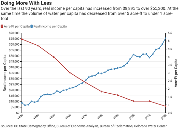
Figure 8
The Cost of Water
Recent price increases and growing uncertainty over future river supplies show that doing more with less will become even more important and more difficult. The cost and availability of water are becoming much larger economic determinants.
Colorado law provides that water is a property right protected by the U.S. and State Constitutions which, in most cases, can be sold or leased separately from its adjoining land. Water cannot be manufactured like other property can be, however. Thus, the buying and selling of water is a unique market.
The market for water varies by location. For example, the Colorado-Big Thompson project allows water consumers in northern Colorado to buy and sell shares of water diverted from the Western Slope. Similar markets don’t exist in other parts of the state; instead, consumers there rely on their municipalities’ abilities to acquire water rights. Generally, existing residents pay utility bills for the costs of delivering water through existing infrastructure and new development largely recovers its costs through tap fees.
Evidence from the price per share from the Colorado-Big Thompson project shows that prices have skyrocketed in the last decade. Between 2010 and 2021, the price per acre-foot grew by 88% from $7,000 to over $58,000. Some water shares, subject to fixed quota contracts (0.70 acre-foot), have sold for over $70,000.[xxii] Figure 9 shows historical share price data for Northern Water’s Colorado-Big Thompson (C-BT) project. Assuming this trend is broadly representative of the rest of the state, it is evident that the price of water has increased rapidly in the past decade and is likely to continue to do so.
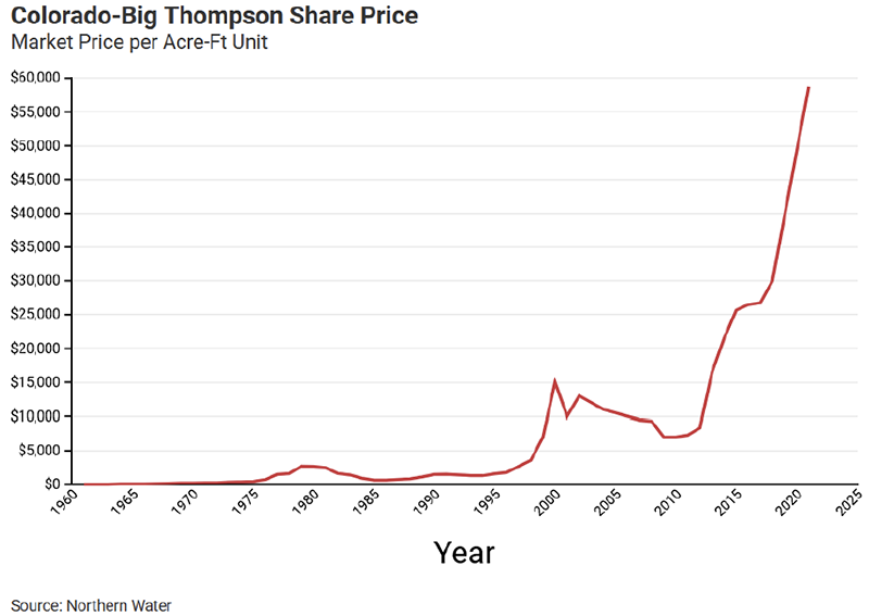
Figure 9. Data sourced from Northern Water’s 2021 C-BT share records.
The price of a water right varies in other parts of the state and is difficult to estimate. There is little public data related to pricing of water rights transactions, so economic analysis of the market is difficult. Added to the cost of the water right itself is the expense of water delivery. Although owners may change the use of their water rights, they must do so in water court and may not injure other water rights in the river. These costs are higher for cases which involve more complexity, more scarcity, and more raw water volume transferred. As such, it should be expected that legal costs will continue to increase in the near future. Even at low water volumes, though, legal costs can be high; under the current system, there is an economy of scale which incentivizes bulk transfers and inhibits small transactions.
Characteristics of Growth
Another expense of the process of obtaining water is related to whatever delivery mechanisms may need to be newly constructed. In this respect, infrastructure costs mirror increases in unit share prices; for example, when considering project costs and acre-feet added, Denver Water’s Water, Infrastructure and Supply Efficiency (WISE) project had a value of $63,800 per acre-ft, which is very similar to the latest prices for which C-BT shares are selling. Amid increasing competition for water and rising prices, new municipal growth will need to curtail its demand for new supplies or the trend of agricultural transfers will only accelerate.
Markets for water exist between buyers and sellers of water rights. In particular, households are impacted by these markets because they pay the utility bills that cover the costs of acquiring rights and maintaining the water infrastructure. Although agricultural users still use greater volumes of water than to other users, there has been a broad statewide trend of reallocation from agricultural uses to municipal uses through acquisition and transfer.
The two main drivers of rising prices are ongoing municipal growth and the willingness of municipal users to pay more. This ongoing shift away from agricultural ownership is particularly reflected in C-BT share ownership, as demonstrated by Figure 10. Furthermore, there are physical implications of amount of irrigated land in Colorado.
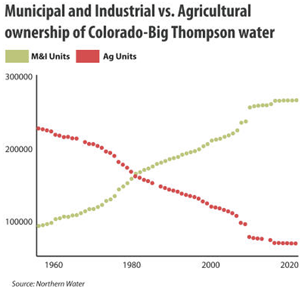
Figure 10. Graphic courtesy of Water Education Colorado[xxiii]
Demand for water for urban irrigation statewide is projected to significantly increase. The South Platte and Metro Basin is projected to encompass 70% of future demand for urban irrigation; at the same time, despite a larger increase in population, the metro area’s share of total usage will decrease, because of faster increases in other smaller counties.
Without changes to urban landscaping (xeriscaping, new water-efficient types of grass, etc.), the demands on the South Platte/Metro Basin in the Denver metro area will severely reduce the amount of water available for agriculture downstream.
Impacts of Competition on Supplies
Because a large portion of water demand growth is municipal, it is worth considering the volumes and costs of the water that will be required for that growth. This can be done with dedicated water estimates. Dedicated water is the amount of water a single housing unit uses per year, on average. As Colorado continues to grow, more housing units will continue to be built. CSI constructed a model to estimate new water demands for housing over the next decade—from 2023 through 2032. The methodology for this model can be found in Appendix J.
Based on historical housing unit ratios (single-family to multi-family), the state’s current trajectory indicates that roughly 100,000 acre-feet of water will be required to support the next 10 years of housing growth. This projected additional volume is subject to change based on a combination of choices made regarding housing type construction and demand management. In general, modeled maximalist scenarios indicate that building more single-family homes will increase water volumes required to support housing growth, whereas a focus on building multi-family homes will decrease required water volumes. Furthermore, water volumes can be reduced by 23.1% if new housing developments become more efficient at using dedicated water at a rate of 0.1 acre-feet/year. In such a scenario of reduced demand, peak price would decrease by roughly 10%. One conclusion is that, in order to reduce the overall stress of obtaining water to support increases in housing growth, an optimal strategy is to prioritize the construction of multi-family homes while continually improving water use efficiency per unit. A realistic perspective, however, indicates that water policy will not always precede lifestyle choices; it is reasonable to consider that per-unit efficiency methods, such as turf removal, may be prioritized over other development restrictions. As long as Colorado is living within its water budget, the market and local communities can make this decision.
Regionalization as Path to Reducing Competition for Water
The prevalent expectation in Colorado is that growth pays its way. Given the projected growing competition for water, it will be essential to adopt across-the-board changes that improve the status quo.
The recurring recommendations in this report align with the broader effort to increase the regionalization of Colorado’s water systems. Those recommendations include establishing regional water authorities, prioritizing regional cooperative water projects, and securing/firming existing supplies. There has been some progress towards these goals and further change has the potential to reduce competition for water and minimize the status-quo price increases in several key ways.
- Increasing economies of scale to drive down transfer and infrastructure costs for acquiring water rights
- Minimizing physical structural impact
- Reducing jurisdictional fights and competition between neighboring cities
- Creating common collection points for re-usable supplies
- Increasing the ability to accomplish projects that otherwise would not be possible as independent entities
Colorado: River Basins and Landscape Analysis & Recommendations
The statewide and regional recommendations in this report outline specific strategies to manage the growing competition for water, which include recommendations about improving water supplies (focusing on firming supplies and creating stronger regional authorities); in particular, regional projects provide a strong investment by combining water sources, infrastructure and economies of scale. Additionally, recommendations about reducing water demand (promoting integrated land use, reducing the amount of dedicated water than houses use) are included.
The Colorado River Basin: An Uncertain Future is Facing the State’s Largest River
The Colorado River is by far Colorado’s largest river system, with a drainage area of over 38,700 square miles, (approximately 37% of the state’s land area). The region is commonly referred to as the Western Slope. Approximately 70% of the state’s surface water originates on the Western Slope, but the region is home to only about 10% of the state’s population. The diversion of water within the basin for mining and irrigation purposes began in the late 1870s and 1880s. Irrigation development accelerated in the early 1900s with the construction of federally financed projects by the Bureau of Reclamation. Today, irrigation is still the predominant use of water on the Western Slope. By the 1890s, irrigators on the South Platte River started looking to the Colorado River headwaters to supplement their native water supplies; this led to the construction of the Grand River Ditch, which moves water from the Never Summer Range in Grand County through a notch in the Continental Divide into the Cache la Poudre Basin. Today, six major transmountain diversions and a similar number of smaller ones are critical water supply sources for both the South Platte and Arkansas River Basins.
Climate change has reduced snowpack and runoff on the Western Slope, as well as in the entire Colorado River Basin. It appears that the southern and western drainage basins may see greater impacts than the more northern basins. For example, the impacts of aridification on the Dolores and San Juan Rivers will likely be greater than on the Upper Yampa and Upper Colorado Rivers; this will have a major negative impact on Colorado River flows outside of Colorado. The Basin’s two large reservoirs, Lakes Mead and Powell, were full twenty-two years ago. They are now at critically low levels. The combination of climate change and uncertainties in the laws and rules that govern water use raises serious questions about the quantity and reliability of Colorado’s share of Colorado River water.
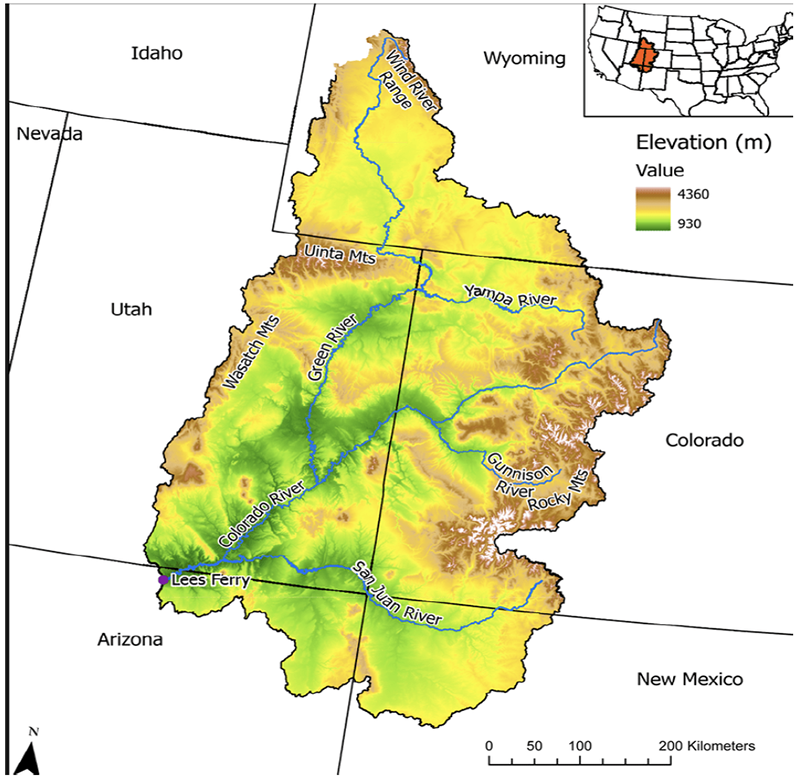
Figure 11. The above relief map of the Upper Colorado River Basin clearly shows why Colorado’s mountains and high valleys provide about 70% of the river’s annual flow. Map courtesy of Colorado River District and Miller et al (2021)[xxiv]
Western Slope Uses
On the Western Slope, the Colorado River is the water supply for approximately 700,000 residents, 800,000 acres of irrigated agricultural lands, and an assortment of mining and industrial uses. Although river flows are normally abundant during the late spring runoff period, water supplies are routinely very limited during the late summer and early fall. Most of the larger irrigation districts and almost all municipal providers rely on stored water to make it through periods of low flow. Non-consumptive instream uses for environmental, recreational, and angling uses are critical to the Western Slope’s multi-billion-dollar recreation industry. The Colorado River Basin has four basin roundtables: the San Juan–Dolores, Gunnison–Uncompahgre, Colorado River Mainstem, and Yampa–White–Green. Each of these subbasins has prepared a detailed Basin Implementation Plan.
The plans propose a mix of projects to address watershed health, streamflow enhancements, the rehabilitation of existing diversion systems, efficiency improvements, and future water needs. Primarily because of the urbanization of existing irrigated lands, total irrigated land within the Colorado River Basin is expected to slightly decline. The Colorado River Mainstem Basin Plan estimates that irrigated lands within that subbasin will drop by 13,000 acres by 2050. The other three subbasins show similar, but smaller decreases.
The State Demographer is projecting that the Western Slope will add about 190,000 people between now and 2050. Because much of the Colorado River Basin’s new urban growth is occurring on previously irrigated lands and because the urbanization of irrigated lands normally results in a net reduction of consumptive use, the net impact of significant Western Slope population growth on the state’s total Colorado River use may be small. This is topic about which additional data and studies are needed.
Transmountain Diversions
Transbasin (also referred to as transmountain) diversions move an average of about 500,000 acre-feet per year out of the Colorado River into the Arkansas and South Platte River Basins for municipal, industrial and agricultural uses. Colorado River imports are critical municipal water sources for Front Range cities from Pueblo to Fort Collins. About 65% of the water supply for Colorado Springs is diverted from the Colorado River. Likewise, about 50% of Denver’s water supply and 25% of Aurora’s are from Colorado River sources. The water system which serves Denver and most of its immediate suburbs, provides water to about 25% of Colorado’s population. Most northern Front Range cities (Boulder, Fort Collins, Loveland, Greeley, and their neighbors) source water from a mix of local supplies and transmountain water obtained from the Colorado-Big Thompson Project (C-BT) and its non-federal companion, the Windy Gap Project. The C-BT, operated by the Northern Colorado Water Conservancy District (Northern Water), is the state’s largest transmountain diversion, diverting an average of about 220,000 acre-feet per year.
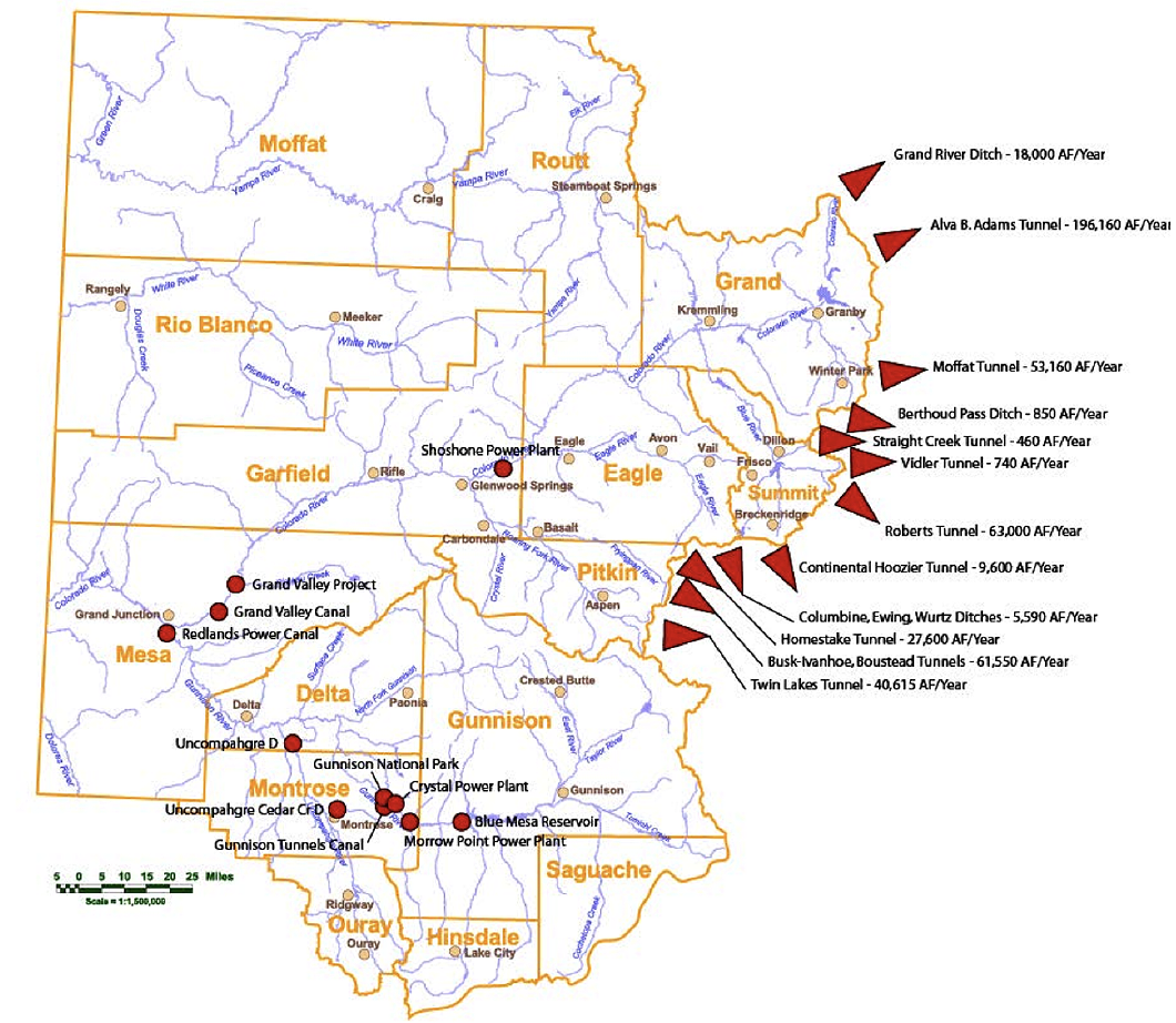
Figure 12. Colorado Transbasin Diversions. Image courtesy of the Colorado River Water Conservation District.
Hydrology and Climate Change of the Entire Colorado River System
The drastic drop in Colorado River flows and water stored in Lakes Mead and Powell are making the national news and Colorado citizens need to understand how they may be affected. About 90% of the river’s flow originates in the mountains and high valleys of the Upper Basin, about 70% of which is in Colorado. Its waters serve over 40 million people and irrigate about five million acres of land in seven U.S. states and Mexico. Its waters are used both within the basin and exported to adjacent river basins for municipal, industrial, and irrigation purposes. The river is fully used. Except during rare wet years or after man-made releases, its waters no longer reach the Gulf of California. When signing the Colorado River Compact in 1922, Commissioner Delph Carpenter estimated that the long-term natural flow at Lee Ferry—the dividing line between the basins—was 17.5 million acre-feet per year. Since the 1920s, the estimate of the natural flow at Lee Ferry has been in continual decline. The long-term 20th-century flow is estimated at 15 million acre-feet per year. In the 23 years since 2000, however, the average has been only about 12.2 million acre-feet per year, an amount far below any that the authors of the Law of the River anticipated. Most of the science anticipates a drier future, but there are still many unanswered questions about future Colorado River flows.
The Law of the River
The allocation and use of Colorado River water is governed by what is referred to as the “Law of the River” (See Appendix G). It is made up of an evolving and sometimes conflicting body of interstate water compacts, federal laws, court decisions, secretarial guidelines, and an international treaty. The law’s cornerstones are the 1922 Colorado River Compact, the 1944 Mexican Water Treaty, and the 1948 Upper Colorado River Basin Compact. The 1922 Compact split the river into two subbasins. The dividing point is Lee Ferry in northern Arizona. The compact apportions 7.5 million acre-feet (maf) of beneficial consumptive use of water each to the Upper and Lower Basins and allows the Lower Basin to increase its use by an additional 1 maf. The compact also places certain obligations on the Upper Basin at Lee Ferry including requirements that the four Upper Division states not deplete the flow of the Colorado River below 75 maf every ten years and that they deliver water to Mexico under certain conditions. There are different interpretations and unresolved disputes concerning the Upper Basin’s Lee Ferry obligations. Under the compact, “present” perfected rights for beneficial use cannot be “impaired” by the compact. A common interpretation of this provision is that perfected rights at the time of the approval of the compact (pre-compact rights) are not subject to curtailment or “call.”
The 1948 Upper Colorado River Basin Compact apportions the Upper Basin’s 1922 Compact share among Colorado, the three other Upper Division States (New Mexico, Utah, and Wyoming), and Arizona, which has a small amount of land in the Upper Basin. Because of uncertainties about the amount of water available in the river and the amount of the Lee Ferry obligations, the 1948 Compact apportions water by percentage. Colorado’s share is 51.75% of the water available for use in the Upper Basin annually.
Crisis on the Colorado River
There is a water supply crisis on the Colorado River caused by combined impacts of climate change on the flows of the Colorado and an imbalance of the demand for water and the available supply. In early 2000, Lakes Mead and Powell, the largest and second largest reservoirs in the United States, were close to full, at about 95% of capacity. After 23 years of the “Millennium Drought,” total reservoir storage is approaching 25% of capacity—a critically low level. In June 2022, Interior Department officials asked the basin states to prepare a plan to cut 2 to 4 million acre-feet per year for water year 2023. Depending on actual runoff conditions, these cuts will be necessary to preserve power generation and protect critical water delivery infrastructure. Beyond the immediate crisis, the Colorado River Basin has a longer-term numerical problem. Under the Law of the River, a total of up to 17.5 million acre-feet per year has been legally allocated but, based on post-2000 hydrology, only about 13 million acre-feet of water is available. Further, climate science is pointing to a drier future. The Millennium Drought may be the new reality, not a drought.
![Figure 13. Graphic courtesy of Arizona Department of Water Resources,[xxv] data compiled by the Bureau of Reclamation](https://commonsenseinstituteco.org/wp-content/uploads/2022/10/water_fig13.png)
Figure 13. Graphic courtesy of Arizona Department of Water Resources,[xxv] data compiled by the Bureau of Reclamation
Colorado River Water Supply Uncertainties
The Colorado River is facing a myriad of interrelated hydrologic, legal, and political uncertainties. These uncertainties cast a dark cloud over basic questions of how much Colorado River water is available for use now and in the future. The reduction of Colorado River flows and the overuse of water in the entire basin, which has drained the two main storage reservoirs, Lakes Mead and Powell, have challenged the sustainability of the river system.
Upper Division State officials believe that the primary cause for the current crisis is that the three Lower Division States (Arizona, California, and Nevada) are using too much water. The numbers support their argument. Based on the most recent data published by the Bureau of Reclamation, the Upper Basin is only using about 4–4.5 million acre-feet per year—less than its 7.5 million acre-feet apportionment—whereas the Lower Basin may be using more than 8.5 million acre-feet per year on the mainstem alone, an amount far more than the Upper Basin’s use and arguably more than its compact apportionment. This does not mean, however, that the Upper Division States are without risk.
What Colorado must avoid is a potential compact deficit—a situation whereby the Lower Division States believe that the four Upper Division States have not met their collective flow obligations at Lee Ferry. If a deficit were to occur, the next step could be extended litigation which would be lengthy and expensive and could result in a curtailment of post-compact water rights within Colorado. Interstate litigation would likely take a decade or more and put the future of water use on the Colorado River in the hands of the Supreme Court or its appointed special master. If the litigation were to result in a curtailment, the economic impacts to the Colorado, South Platte, and Arkansas River Basins could be very significant. A major portion of Colorado’s Colorado River uses are post-compact water rights and subject to being curtailed (shut off). These post-compact rights include almost all the transmountain diversions, a high percentage of the Western Slope’s municipal uses, most snowmaking uses, and Western Slope reservoirs that provide critical late-season irrigation water.
For a more detailed discussion of the Colorado River, see Appendix G.
Colorado River Basin Recommendations
- Colorado must make firming its existing Colorado River uses a Priority.
- As a top priority, Colorado should focus on minimizing or removing the curtailment threat to post compact water users. Ideally, such provisions could be made part of the post-2026 operating guidelines for the Colorado River system that are currently being renegotiated by the basin states and other stakeholders.
- Recognizing that an interstate agreement may not be possible, Colorado should in parallel pursue an intrastate plan that covers at least the critical economic uses being served by these projects and provides strategic infrastructure to manage supplies.
- Colorado must be fully prepared to use less Colorado River water.
- Colorado’s water management and administrative officials and its major water agencies that use and manage Colorado River water need to be fully prepared for a future wherein Colorado has to reduce its consumptive uses.
- The State Engineer should begin an informal consultation process with key Colorado River water users. Water users are divided about whether the State Engineer should promulgate draft Colorado River Compact rules and regulations. Many water users believe that such an action is necessary and essential to prepare the state for potential curtailment. Further, it would provide a basis for evaluating the differences between a “strict compliance with the compact” future and alternative futures that might result from interstate or intrastate negotiations. The counterarguments are, first, that draft rules and regulations will likely be very controversial and cause internal fights in Colorado at a time when it’s critical that the state be unified, and second, that the promulgation of draft rules and regulations would be very resource- and data-intensive and take valuable resources away from the state’s efforts to negotiate the post-2026 operating rules for the Colorado River.
- The Colorado River is not a source of “new supply” for either Eastern Slope or Western Slope uses.
- Under a future wherein climate change and aridification continue to reduce the flow of the Colorado River, Colorado will have to carefully manage and possibly reduce its consumptive uses of the Colorado River system to maintain compact compliance.
- All water needed for future growth within the Colorado River Basin and for increasing transmountain diversions to the South Platte and Arkansas Basins will most likely have to be offset by reductions and reallocations of existing uses.
- Colorado should review and change legal limitations on existing water infrastructure that may not make sense in a warming climate.
- The foundation of Colorado water law is sound and allows for some flexibility to accommodate many changing societal needs.
- In an era of drought, Colorado should, where possible, remove unnecessary restrictions and supply limitations.
- Many of Colorado’s existing water infrastructure was authorized, designed, and permitted for a river and a climate that no longer exist. For example, the Mountain Ute Tribe in southwestern Colorado owns water in Lake Nighthorse that is currently unused. It also operates a farming enterprise that uses irrigation water provided by the Dolores Project. In recent years, drought has significantly reduced irrigation water deliveries by the Dolores Project and impacted the financial viability of the enterprise. It is technically feasible for the tribe to deliver its unused Lake Nighthorse water to the enterprise via the San Juan River then pump it a short distance to its farm, but, because of agreements, decrees, and federal laws negotiated in the 1970s and 80s, it is prohibited from doing so. Though the limitations from 1970s and 80s may have been appropriate at the time, do they still make sense today? If not, should the limitations be changed? We suspect that the innovative use of other existing projects is handcuffed by similar decree limitations and agreements.
South Platte River Basin: Can Agriculture Survive on Colorado’s Workhorse River?
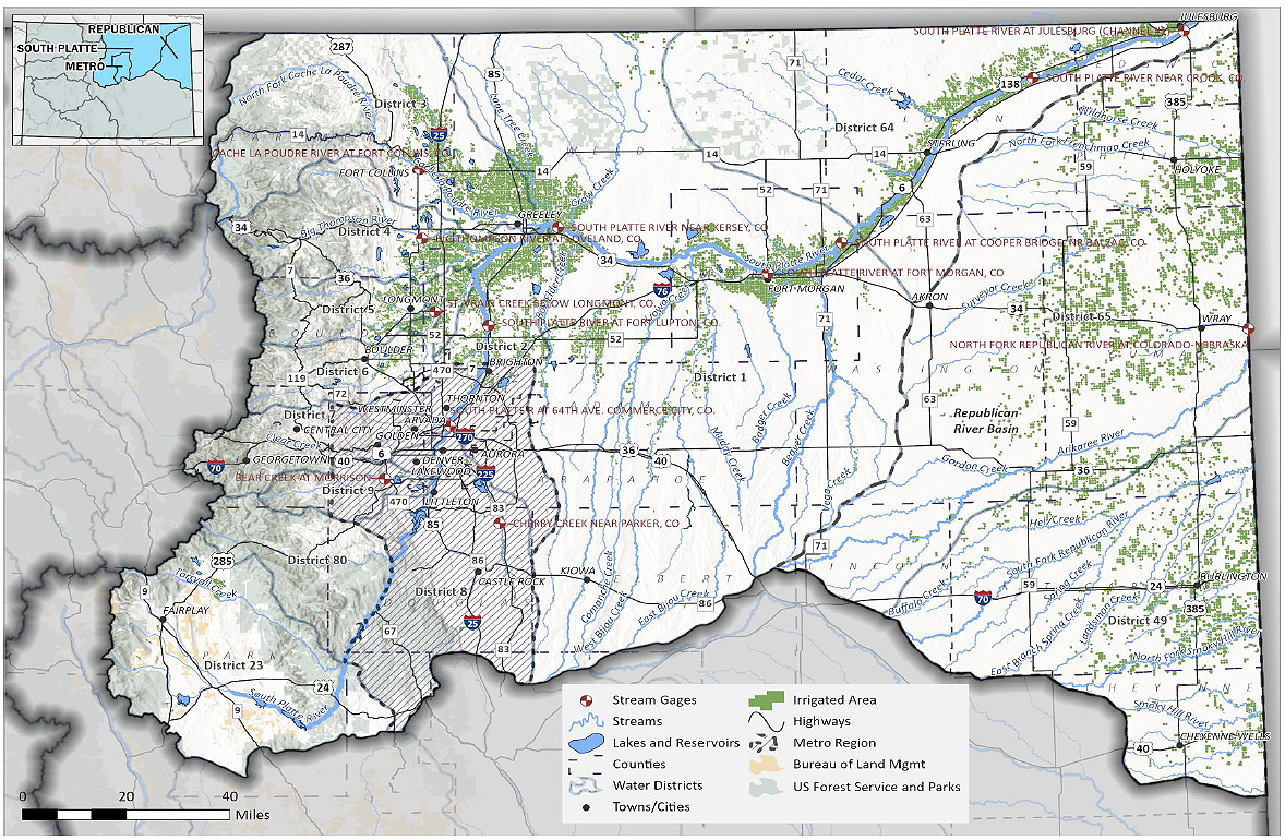
Figure 14. Map of South Platte Basin Roundtable. Image courtesy of Colorado Department of Natural Resources’ South Platte Implementation Plan
Geography and Hydrology
The South Platte River begins in the headwaters of the Mosquito Range above South Park and extends over 350 miles from the high Rocky Mountains to the eastern plains and into Nebraska just after Julesburg (Figure 14). It gets its name from early French explorers, who called the river the “platte” (flat) because of its expanse. In April 1889, humorist Edgar Wilson “Bill” Nye coined the description of the Platte River as “a mile wide and an inch deep.” 70% of the water supply in the basin comes from melted snowpack. Supplies in the basin varied significantly each year. The addition of transbasin water from the Colorado River transformed the river into a more reliable workhorse. To date, the Basin receives over 350,000 acre-feet (af) of transbasin water each year, making up 28% of the water volume available in the region. A common adage provides that every drop of water in the South Platte rivers is used and reused six or seven times, due to the continued cycle of return flows and municipal effluent.
Under the metro-Denver area lay four nonrenewable groundwater basins called the Denver Basin Aquifers. In the 1980’s water leaders understood the danger of draining aquifers and advocated for state legislation to control the use. Unfortunately, the law passed was too generous in allowing withdrawals and the groundwater resource is quickly depleting. Douglas and Arapahoe Counties are particularly reliant on this resource.
Several studies have reported on the effects of climate change to the water supply in the Platte River basin in Colorado. IPCC models indicate an increase of 4 to 8 degrees Fahrenheit with greater precipitation (not necessarily snowpack) in the winter and spring and lower precipitation in the summer. Higher temperatures mean higher water demands for crops, lawns and gardens. Scientists predict that there will be a 10% decrease in streamflow volume. Climate change also leads to a greater increase in flooding with a 29% increase in the 100-year peak flows. South Platte flows could decrease by 34% by 2090.[xxvi]
History of development
The Kiowa, Cheyenne and Arapaho Indian tribes traditionally made the South Platte basin their home. Gold in the Rocky Mountains brought miners in the 1850’s. Settlers came into the basin and began irrigating fields to produce food for those miners, as well as travelers heading further west. The Union Colony (now Greeley) promoted itself on the east coast and brought in even more people to work on the land. At the center of several major railroad junctions, Denver quickly developed into a population and industry center, at first dependent on products from farming and ranching in the Basin.
The sharing and sometimes fighting over water in the river, led the early territorial courts to adopt the doctrine of prior appropriation to resolve disputes. In fact, this is sometimes called the Colorado Doctrine. Adopted from common mining law, the doctrine provides that the first to use the water has the better right.
As cities grew, they developed their own projects for a water supply. There were few joint projects, if any. Water decrees and agreements restricted municipal use to the boundaries of the city, making joint sharing of water and facilities difficult. Competition for available supplies is fierce in newer smaller towns, now growing at faster rates.
Another challenge municipalities are starting to address is the disconnect between city planners and their water utilities. Cities wanted to thrive with new development and industry and governing entities would approve development plans. Water utilities were expected to come up with water supplies to support those plans. Denver Water is the utility to obtain and deliver water supplies to Denver. However, planning for housing, landscape and other services falls under the City and County of Denver (Community Planning and Development, Parks and Recreation, Department of Transportation and Infrastructure). Wastewater treatment is handled by the Metro Wastewater Reclamation District. The City and County of Denver has developed its One Water Plan which breaks down the individual agency silos and provides cooperative measures to manage the entire water cycle. City planners, designers, wastewater treatment professionals, along with the Colorado Water Conservation Board, the Mile High Flood District and the Greenway Foundation plan for the sustainable use and protection of water for health, recreation, and healthy watersheds.[xxvii]
In order to secure more stable supplies of water several transbasin diversion projects were developed. Denver Water imports about 140,000 maf a year into Dillion and Gross Reservoirs.[xxviii] The C-BT operated by the Northern Colorado Water Conservancy District (Northern Water), is the state’s largest transmountain diversion with a water right to import up to 310,000 af/yr; however, the average diversion has been about 220,000 af/yr. As originally configured in 1938, 85% of the project’s 310,000 shares were owned by agricultural interests (individual farmers and ditch companies) and 15% by municipalities within the district. Today, municipal and industrial interests own over 75% of the project shares. The Windy Gap project, operated by Northern Water’s municipal subdistrict, diverts another 40,000 acre-feet per year (when fully used) using the C-BT facilities to move the water to its members.[xxix] Both Denver Water and Northern Water are currently building two projects to “firm-up” their Colorado River supplies.[xxx] Firming one’s water supplies involves creating infrastructure to better store and manage their existing transbasin supplies for more reliability.
Population and growth
The South Platte River provides a water supply to the most productive agricultural basin, while also being the most heavily populated industrial area of the state. The Basin is a strong economic resource for the state. In 2005 the basin had an annual value of sales and services well over $250 billion. (CWP)
Currently over 3.8 million people live in the basin, 70% of Colorado’s total population.[xxxi] The state water plan estimates number of people could grow by up to 70% by 2050. This fast-paced growth challenges the water supply in the basin. Municipalities have implemented conservation measures to the degree that their population has increased, while daily water use has been reduced or at least remained stable.
The Front Range is the heartbeat of Colorado’s economy. Individual municipalities work within their own boundaries and systems to provide sufficient water supplies for their current and future population. Competition among entities has been fierce with expensive legal battles in water court. Many water decrees and agreements restrict a municipal’s use of a water right to within its boundaries. Also, the competition for new industry within their boundaries has pitted one city against another in obtaining water supplies to increase the city’s own economy. New development should be required to be water smart. The cities of Aurora, Westminster and Thornton have developed programs to reduce water use in current structures and facilities and control new development. In Douglas County, Sterling Ranch has set a new standard for low water use. Castle Rock and Parker have now implemented closed loop systems where all insider water use is reclaimed and used to extinction.
As smaller communities developed, surface water supplies were in short supply and looking to agricultural water rights to buy-and-dry became the go-to solution. Some of these entities have relied mostly on the Denver aquifer, which is rapidly depleting. More to the north, a few growing entities have a nearly single reliance on transbasin water through the C-BT project, which is meant to be a supplemental supply.
About 350,000 acre-feet of water is transported to the South Platte from the Colorado River. Under Colorado water law, return flows from those diversions can be reused to extinction. Because the C-BT project was built as a supplemental water supply and to increase the reliable flows in the South Platte River, those return flows are not allowed to be captured and reused after the initial use. However, other entities do not have that restriction, which could provide water supplies for a joint project. The WISE (Water, Infrastructure and Supply Efficiency) project did just that. Aurora, Denver and eleven Douglas County entities partnered to combine their unused water supplies and excess capacity in their facilities to help those communities with an over-reliance on nonrenewable groundwater in the Denver basin.
Environmental values
The South Platte River basin contains a rich environmental and recreational playground for northern Colorado. Portions of the Poudre River have a federal designation of a Wild and Scenic River, the only one in the state. The South Platte provides excellent hiking, rafting, and fishing experiences. Once highly polluted, the river runs through Denver and has experienced a rebirth with concerted efforts to clean up the river and its environment. The basin is also home to the High Plains, with canyons, buttes and several natural lakes. The Pawnee National Grasslands near Greeley provide a natural prairie landscape.
Agriculture
The South Platte Basin provides water to 850,000 acres of irrigated farmland. Due to the increase in urbanization of irrigated lands, that number will be reduced by an estimated 106,000 acres by 2050. Over 60 percent of these 106,000 urbanized acres are projected to occur in the St. Vrain River, Big Thompson River, and Cache La Poudre River basins. In 2007, agriculture in the South Platte basin contributed about $4.2 billion to the state’s economy.[xxxii]
Agriculture has been the go-to plan for growing municipalities to obtain water resources. Generally, there are three options in obtaining water rights from agriculture. First, under what is known as buy-and-dry, farmers sell the land and accompanying water rights. Second, they also may choose to sell just their water rights and either continue farming using dry land techniques or rent back the land from the buyer knowing in a dry year the water goes to the cities. Either of these scenarios forces the buyer to change the use of the water right in water court, which in this Basin is a lengthy and expensive process. Recognition was slow regarding the negative effects of buy and dry to the agricultural economy and surrounding rural communities. A third evolving method is described as alternative transfer methods (ATMs), which includes interruptible supply agreements between the municipal water supplier and the agricultural water user, resulting in temporary fallowing of land, but at too slow a pace and at a significant cost.[xxxiii] The biggest impediments to the implementation of water sharing agreements are the lack of infrastructure, storage in particular, and the length of term required in an agreement with a municipality.
The South Platte River Compact
In the early 1910’s Delph Carpenter became Colorado’s interstate commissioner, tasked with negotiating agreements with neighboring states sharing interstate rivers. His successful interaction with Nebraska led to the South Platte Compact. Carpenter studied the South Platte River in Colorado and realized that it has distinct upper and lower segments. The dividing line between the two segments was at a point where, prior to the development of irrigated agriculture, the river would disappear into the riverbed in the summertime. This dividing line between the upper and lower segments occurs approximately 80 miles upstream of the Colorado/Nebraska state line at the Morgan/Washington County line. The irrigation of the lower segment depends heavily on the return flows occurring from upstream irrigation and Carpenter convinced Nebraska that their state benefitted from those return flows as well. These facts are acknowledged by the compact in that flows in the upper segment in Colorado will not be curtailed to meet any compact delivery requirements. Signed in 1923, the South Platte Compact established delivery requirements for Colorado only for the irrigation (April 1 to October 15) season. Colorado is required to curtail diversions beginning a few miles downstream of Brush that are junior to June 14, 1897, in order to meet the delivery requirement of 120 cubic feet per second at the state line gage. Colorado has consistently met these obligations. In the non-irrigation season, Colorado has no delivery obligations.
In order to meet delivery requirements under the Compact, many wells pumping out of the alluvial aquifer must replace their out-of-priority depletions. One of the methods is to capture flows in the non-irrigation season and recharge the underlying aquifer. This provides more flows during the irrigation season, protecting senior water rights and compact deliveries.
Within the last year, the Nebraska governor announced that his state would be reviving the Perkins County Canal clause of the Compact, which provides that Nebraska may divert up to 500 cfs of water from the South Platte in Colorado for irrigation in Nebraska, subject to 35,000 acre-feet of future storage by Colorado. Apparently, the concern stemmed from the South Platte Basin Implementation Plan developed by the South Platte Roundtable and the 282 possible projects listed therein to better manage water resources. Many of these projects are in initial planning phases and/or are in the upper segment of the river. The Nebraska legislature appropriated $50 million to study the Perkins County Canal project. Concerns from the state of Colorado and its citizens are that the project is probably not feasible. Since the water must be for agricultural use, storage would be needed but does not yet exist. Also, the project would affect the recharge operations in the lower segment of the river.
Platte River Recovery and Implementation Program (PRRIP)
In 1973 Congress enacted the Endangered Species Act to protect and recover endangered and threatened fish, wildlife and plants and the ecosystems on which they depend. Before taking any action (including funding projects) that may jeopardize any listed species, federal agencies must consult with the U.S. Fish and Wildlife Service and/or NOAA Fisheries Service.
Implemented in 2007, the PRRIP is a program to protect and restore habitats along the South Platte River in Nebraska for four threatened and endangered species, three birds and one fish: the whooping crane, the least tern, the piping plover and the pallid sturgeon. The program provides ESA protections for existing and new uses in three states. Colorado, Nebraska, Wyoming, and the federal government entered into an agreement to maintain a collaborative adaptive management program to recover and protect those species. [xxxiv]
South Platte Basin Implementation Plan (SPBIP)
The Plan incorporates information from the South Platte Basin and Metro Roundtables and includes the Republican River Basin. Population and industrial growth combined with existing water scarcity provides a challenge for the future under all scenarios. Future scenarios in the Plan predict that the South Platte basin can experience water supply gaps from 600,000 to over 1 million acre-feet.[xxxv] As the Basin continues to grow in population and industry, irrigated acres for farms and ranches will decrease, caused by urbanization into adjacent farmland and municipalities buying and drying farms for the water supply. The SPBIP listed 282 possible projects to help meet the water gap, with 39 top tier projects that are ready to launch. Projects include;
- The aquifer storage and recovery wells for the town of Castle Rock, to store renewable supplies through injection into the aquifer for future use
- The Denver One Water Plan (described above)
- Northern Water’s Windy Gap Firming project
- Denver Water’s Moffat Collection System project
- The City of Greeley’s water conservation program
- The South Platte Protections Plan to protect river-related values identified by the U.S. Forest Service.
Economic Consequences
The 2019 technical update to the Water Plan predicts the economic loss if the South Platte Basin is unable to supply the water gap:
- Reduced Economic Output: $43 billion to $72 billion
- Reduced Gross Regional Product: $25 billion to $41 billion
- Reduced Employment: 273,000 to 442,000 jobs
- Reduced Labor Compensation: $16 billion to $27 billion
- Reduced State and Local Tax Revenues: $2.7 billion to $4.7 billion
- Reduced Consumer Welfare: $0.7 billion to $1.3 billion
Given this era of aridification, these are serious hits to Colorado’s economy.
Conservation and Reuse
One of the important strategies to increase water supplies in the Basin is water conservation and reuse. Under Colorado water law, water diverted from the South Platte is used once and any water’s first use not consumed by plants, people or evaporation, then must flow back to the river. These flows are known as return flows and are what keep the South Platte River viable. However, when water is diverted from another basin (e.g. transbasin water from the Colorado River to the South Platte Basin), the law provides that transbasin water can be used and reused to extinction. So long as the diverting entity can control the return flows of the transbasin water, it can keep using the water in its system, collecting and redistributing the water until it is consumed. These transbasin flows have contributed to a sustainable economy for the South Platte basin.
The Front Range water providers have been innovative in their efforts to conserve water within their boundaries. Many pay customers to put in water efficient appliances and have a focused effort on educating their constituents on how to reduce water demands. Water conservation efforts focus on open spaces, parks, lawns and gardens that consumptively use most of the water in neighborhoods. There are many success stories. Since 2000 Denver Water has reduced its per capita water use 36%, Aurora by 36% and Pueblo by 32%.[xxxvi] These savings allowed those municipalities to grow without drawing more water from the system. Much of the growth is vertical, which greatly reduces the need for lawns. Those entities have pledged to reduce the quantity of non-functional turf grass by 30% by replacement with drought- and climate-resilient landscaping, while maintaining urban landscapes and tree canopies. Douglas County has shown, with Sterling Ranch, that water requirements can be reduced by almost half the current usage by using demand management with land planning and technology. Further, Douglas County is the home of the State’s rainwater harvesting pilot project which shows great promise for new local water supplies without harming senior water rights.[xxxvii]
Cooperative Projects
The South Metro Water Supply Authority was formed to facilitate collaborations on new projects and initiatives to deliver sustainable water supplies to its members, with 15 entities providing water services to their customers. The Authority has assisted in developing renewable water supplies for its members, managing water quality, conserving and using water efficiently, and developing new surface and underground storage. One of those projects is the Water Infrastructure and Supply Efficiency (WISE) Project. It is the first project in the metro Denver area to combine use of facilities and water supplies to reduce the reliance on nonrenewable groundwater to several south metro communities. It also provides back-up supplies for Denver Water and uses Aurora’s Prairie Waters Project, an innovative potable reuse facility.[xxxviii] Potable reuse facilities sanitize and reuse municipal wastewater in contrast with municipal systems that sanitize wastewater, release it to stream, and recoup it downstream for reuse.
The South Platte Regional Opportunities Water Group (SPROWG) consists of regional water providers from both municipal and agriculture sectors that have banded together to investigate regional supply concepts. Their goal was to maximize the effectiveness of available water in the South Platte Basin, to minimize traditional agricultural buy-and-dry and to evaluate cooperative multi-purpose projects to fill the water supply gaps. Completed in 2020, a feasibility study evaluated governance structures, water treatment strategies, and possible regional projects to explore.[xxxix] As a result of this work, the City of Parker and the Lower South Platte Water Conservancy District joined to propose the Platte Valley Water Partnership Project to make joint use of water in the Basin.[xl]
Northern Water’s Southern Water Supply Project is a cooperative effort of Northern Water and several communities on the Front Range. It carries Windy Gap Project and Colorado-Big Thompson Project water 110 miles from Carter Lake to those communities. Acting as a financial and project manager, Northern Water owns and operates the project, while the communities pay their proportionate shares of operations, maintenance and replacement costs.[xli] The Northern Integrated Supply Project is another cooperative effort to store South Platte River supplies in high flow years, provide more flows through Fort Collins, and helps to minimize agricultural dry-up.[xlii]
The Chatfield Storage Reallocation Project is a successful partnership with the U.S. Army Corps of Engineers, the State of Colorado, and municipal entities that provides an additional 20,600 acre-feet of water supply storage just upstream of Denver, as well as provide environmental and recreational enhancements along the South Platte River.[xliii]
Greeley’s public private partnership with the Terry Bison Ranch allows water to be stored and then recovered in a large aquifer unconnected to surface water, lying under the Ranch on the border of Colorado and Wyoming. The project protects the water quality of the aquifer and eliminates the evaporation component of surface water reservoirs.[xliv]
South Platte River Basin Recommendations
- Water users and water providers should work cooperatively and collaboratively with the goal of optimizing the beneficial use of available water resources to form regional solutions. The WISE project is a good example of what can be done. The state resource agencies and the legislature should provide economic support and incentives and give priority to joint-use projects.
- The South Platte Basin should consider a basin-wide regional water management/policy agency or agencies, such as an existing water conservancy district, or a newly formed water conservation or conservancy district, that would operate as an umbrella district(s) and would have the statutory authority to:
-
- Optimize the use of fully reusable water through the development of a reusable water “bank”, build and operate reuse and recycle projects.
- Develop and operate regional surface and aquifer storage projects.
- Build and operate regional supply and interconnect projects such as the proposed Colorado Springs “loop” project and where feasible, joint water treatment plants.
- Build interconnect projects and develop emergency backup water supplies.
- Sponsor incentive programs to remove and replace ornamental turf landscapes that consume less water. Where feasible bank or store the saved water for new uses.
-
- Consider legislation to facilitate interactive use of water rights for municipal entities without harming existing vested water rights. Failed House Bill 20-1097 attempted to do this by allowing for adjudicated consumptive use to be used, leased or exchanged, to provide for more efficient management of water supplies. Water users and the legislature should work together to enact laws that can facilitate interactive use of fully reusable water (transbasin or adjudicated consumptive use).
- The state resource agencies, (CWCB and State Engineer) and water providers should work with federal owners of reservoirs, power plants and facilities to provide more storage and manage water more efficiently. The Chatfield project is a good example.
- The state resource agencies, the legislature and water entities should promote, build and use additional storage and structures for multi-beneficial purposes to better manage water and firm (make more reliable) existing supplies, including both in-basin and Colorado River transbasin supplies. This is currently happening with Denver Water’s Gross Reservoir and with Northern Water’s Chimney Hollow Reservoir. The Northern Integrated Supply Project (NISP) is an example of a multi-purpose project relying only on South Platte River supplies to provide clean water to numerous growing communities, recreational benefits, and improving flows for esthetic purposes through Fort Collins.
- Consider statewide legislation to set demand management standards for new construction and development. Many cities like Aurora require stricter standards but those goals are thwarted when developers outside the city’s jurisdiction continue to develop large blue grass areas.
- State resource agencies and the legislature should promote more study and investment in technology focusing on how to store and recover water in the Denver Basin aquifers. More projects like Greeley’s aquifer storage and recovery should be explored.
- Water resource agencies, the legislature and water providers should develop more strategic storage to adapt to the changing climate and aridification, including storage in aquifers, like the Terry Bison ranch project which is a public-private partnership.
- Where feasible and considering effects on the regimen of the river, the State should incentivize agricultural water users to promote more efficiency, using technical delivery improvements, rotational fallowing, and switching to crops that are more drought resistant.
The Arkansas River: Operating Under the Thumb of a Supreme Court Decision
The Arkansas River originates in the high mountains north of Leadville, Colorado. From there it flows south toward Salida, then turns east to cut deep canyons under the Royal Gorge Bridge, before becoming a plains river east of Pueblo. The river reaches the border with Kansas near Holly then continues its 1500-mile journey flowing through Kansas, Oklahoma, and Arkansas to its confluence with the Mississippi River. The Arkansas River basin in Colorado drains 28,000 square miles, about 27% of the state. The basin is home to about a million people, including Colorado Springs, the state’s second most populous city and over 700,000 acres of irrigated lands. Private irrigation development had fully developed the available water in all but the wetter years by the 1880s. Native water uses in the basin are subject to the 1948 Arkansas River Compact between Colorado and Kansas. The upper reach of the river supports over 100 miles of a continuous Gold-Medal fishery and the nation’s largest commercial river rafting industry.
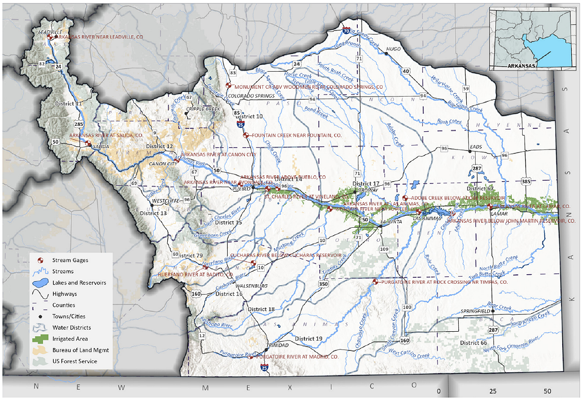
Figure 15. Map of the Arkansas Basin Roundtable. Image courtesy of Colorado Department of Natural Resources’ Arkansas Basin Implementation Plan
Hydrology
The small portion of the watershed north of Salida, that drains Colorado’s highest mountains (<5% of the basin), produces well over half of the river’s annual flow. At Salida the annual flow since 1988, including imported water, has averaged 618,000 acre-feet per year, falling to about 404,000 acre-feet per year at Pueblo. As the river flows from Pueblo to the Kansas border, agricultural diversions (all pre-1949) reduce the flow to about 101,000 acre-feet per year below John Martin Reservoir at Granada[xlv]. Although most experts believe that the river’s flows are being impacted by climate, the gauge records at these locations show no statistically significant trends.
Basin reservoirs are essential to the water management in the basin. The two largest reservoirs are Pueblo Reservoir with a capacity of 347,000 acre-feet and John Martin Reservoir with a capacity of 335,000 acre-feet. Pueblo Reservoir, built by the U.S. Bureau of Reclamation, is a component of the Fryingpan- Arkansas Project. In addition to regulating project water imported from the Colorado River, the reservoir is used to manage the winter water program and to facilitate and manage exchanges of water.
The Arkansas River Compact
Unlike other compacts, the Arkansas River Compact does not apportion a specific amount of water between the two states, nor require a specific flow at the state line. The intent of the compact is to protect existing uses at the time the compact was approved in 1949. Therefore, the compact allows additional uses (after 1949) only to the extent that waters of the river are not “materially” depleted.[xlvi] The compact puts in place the procedures for the operation of John Martin Reservoir, built and operated by the U.S. Army Corp of Engineers for the purposes of flood control and to provide storage for Kansas and Colorado to manage the waters of the Colorado River. The compact set up the Arkansas River Compact Administration Agency for compact administration.
In 1985 Kansas filed suit against Colorado claiming that it was in violation of the compact. In 1994 Special Master Arthur Littleworth ruled that over the period of 1950-1985 Colorado violated the compact by allowing the pumping of groundwater that is hydrologically connected to the Arkansas River. In 1995 the Supreme Court agreed with the special master. The case continued through 2009 before all the issues were settled. The consequences to Colorado for being found in violation of the compact were significant. In addition to the loss of agricultural water and production, Colorado ended up paying Kansas $34.6 million in damages and through the State Engineer’s Office, strict rules and regulations have been put in place to maintain compact compliance.
Basin Water Use
The Arkansas River Basin is a water-short basin, highly reliant on transmountain diversion imports from the Colorado River. In dry years 65% of Colorado Springs’ water supply is derived from the Colorado River. Complicating matters, there are exports out of the basin into the South Platte River by the City of Aurora. The basin is facing significant water supply challenges on several fronts: Its population is expected to grow to between 1.4 and 1.7 million people by 2050 according to the basin plan. Much of this growth is expected to occur in suburban Colorado Springs and unincorporated El Paso County, an area currently reliant on non-renewable Denver Basin ground water. The Arkansas River Compact precludes the development of any additional native water. Both its native headwaters and its Colorado River sources may be subject to declining water yields in the future due to climate change. The basin’s larger transmountain import projects are vulnerable to a possible curtailment for Colorado River Compact compliance purposes. The bottom line is that the basin will need to accommodate new growth, replace existing non-renewable groundwater sources with renewable surface supplies, comply with restrictions of the Kansas v. Colorado litigation, protect its remaining agricultural economy, and continue to manage and optimize stream flows for its booming headwaters recreation industry, all with less water in the future.
Transbasin Diversions
The Arkansas River Basin is highly reliant on imported water from the Colorado River Basin and is also a source of water that is exported to the South Platte River Basin. Historically, imports from the Colorado River have averaged about 120,000 acre-feet. The following table lists the diversion systems. One half of the diversions from the Homestake and Busk-Ivanhoe Systems, the Columbine Ditch yield, and a small portion of the Twin Lakes Tunnel diversions are rediverted from the Arkansas River basin into the South Platte Basin for use by the City of Aurora, about 13.5% of the total.
Table 2. Data sourced from the Southeastern Colorado Water Conservancy District
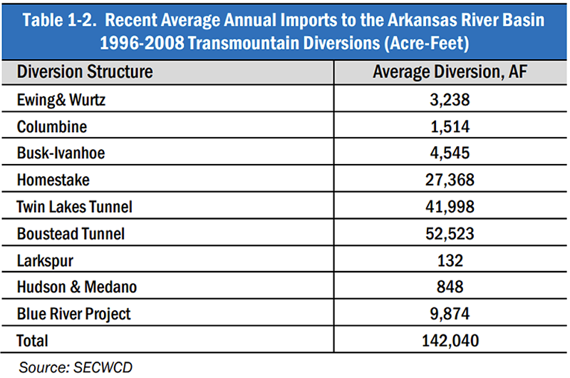
Additionally, in 1989 Aurora purchased 58% of the Rocky Ford Ditch, one of the most senior water rights in the basin. In 1999 Aurora purchased another 36% of the reservoir where it can be pumped over Trout Creek Pass into the South Platte Basin. [xlvii] Today, Aurora gets about 25% of its system yield from the Arkansas Basin.[xlviii] Along with similar purchases by Colorado Springs, Pueblo, and Pueblo West, the Arkansas Basin has become the poster child for negative impacts of “buy and dry” on local communities.
Arkansas River Basin Plan
The Arkansas River Basin Roundtable has developed a detailed and innovative Basin Implementation Plan. The plan recognizes that the basin is heavily reliant on imported water and that it is likely facing a future with less water due to the impacts of climate change. Cooperative water management projects and innovation have always been necessities in the Arkansas River Basin. Examples are the winter water program, Colorado Spring’s Southern Delivery System, the Arkansas Valley Conduit, the John Martin Reservoir Permanent Conservation Pool, and most recently the Super Ditch concept being sponsored by the Lower Arkansas Valley Water Conservancy District. The Super Ditch is an alternative to buy and dry where municipalities can lease agricultural water from a consortium of ditch companies, without a permanent sale of the water rights or dry-up of the underlying lands. The basin plan includes a focus on optimizing the use of existing storage and the development of new storage alternatives including aquifer storage alternatives. Given the challenges facing the basin: the impacts of climate change on both water supplies and demands, the vulnerability of the basin’s imported water, and the restrictions on the use of native water, it is time for the Arkansas Basin to take its already high level of cooperation and innovation to the next level.
Arkansas Basin Recommendations
- The Arkansas Basin is highly reliant on Colorado River Projects that are increasingly vulnerable to curtailment (a compact call). The State of Colorado should prioritize pursuing an interstate agreement that minimizes or eliminates the risk of a curtailment of critical post-compact uses, including the projects that divert water from the Colorado River to the Arkansas Basin.
- Absent an interstate agreement the Arkansas Basin should work with the State, the South Platte River Basin and the Colorado River Basin for an intrastate agreement or plan that in the event of a curtailment minimizes the economic impacts.
- The Arkansas Basin should consider a basin-wide regional water management/policy agency or agencies, perhaps a water conservation district, that would operate as an umbrella district(s) that would have the statutory authority to:
- Optimize the use of fully reusable water through the development of a reusable water “bank”, build and operate reuse and recycle projects.
- Develop and operate regional surface and aquifer storage projects.
- Build and operate regional supply and interconnect projects such as the proposed Colorado Springs “loop” project and where feasible, joint water treatment plants.
- Build interconnect projects and develop emergency backup water supplies.
- Sponsor incentive programs to remove and replace ornamental turf with landscapes that consume less water. Where feasible bank or store the saved water for new uses.
The Rio Grande Basin – Struggling to Find a Sustainable Future
The Rio Grande starts high on the leeward side of the San Juan Mountains west of the town of Creed. The river drops steeply into the San Luis Valley before turning south on its long 1900-mile journey to the Gulf of Mexico. The San Luis Valley is a high elevation desert (average elevation 7500’) tucked in between San Juan, Sangre De Cristo, and La Garita Mountain Ranges. The Rio Grande Basin, often referred to as Colorado’s “South Slope,” covers about 7500 square miles, about 2/3rd (5100 square miles) is technically within the Rio Grande drainage basin. The remaining 1/3rd is the Closed Basin. A basin with no natural outlet to the Rio Grande (an endorheic basin). The Rio Grande drainage basin and the Closed basin are hydrologically connected through diversions and ditches that carry river water into the closed basin, primarily to recharge aquifers and the Closed Basin Project which exports surface water out of the closed basin to the river for compact compliance purposes.
Although the Rio Grande Basin covers about 7% of Colorado’s land area, its population of about 46,000 is less than 1% of the state’s. The largely rural basin’s economy is reliant on tourism and 520,000 acres of very productive irrigated lands. The region is one of the nation’s largest producers of potatoes.
The Rio Grande Basin is facing a water use crisis. Existing agriculture is over-drafting the available groundwater in the Closed Basin and the combination of climate change, and the 1938 Rio Grande Compact among Colorado, Texas, and New Mexico is restricting and slowly diminishing the amount of surface water available for consumptive uses within the basin. To reach a long-term sustainable level of groundwater use, the basin has adopted an aggressive, but painful, program to reduce agricultural depletions by purchasing or fallowing existing farmlands.
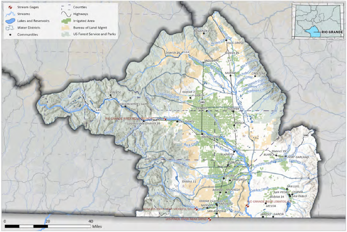
Figure 16. Map of the Rio Grande Basin Roundtable. Map courtesy of the Colorado Department of Natural Resources’ Rio Grande Basin Implementation Plan.
Rio Grande Hydrology
Most of the flow of the Rio Grande and its largest tributary, the Conejos River, originates as snowmelt on the eastern slopes of the San Juan Mountains. Colorado watersheds provide about 60-65% of the natural flow of the Upper Rio Grande(source: West-Wide Climate Risk Assessment: Upper Rio Grande Impact Assessment, USBR, December 2013). Unlike the neighboring Colorado River, there are few estimates of the natural flow of the Rio Grande. A 2018 study estimated the 1900- 2010 average natural flow at the border with New Mexico is about 1.0 million acre-feet per year. Colorado’s estimated consumptive use from 1950-2010 was 500,000 acre-feet per year[xlix].
Like the Colorado River, the flow of the Rio Grande is being impacted by climate change. The basin is undergoing aridification. The long-term average natural flow is declining. The annual hydrograph is becoming more variable, and the runoff is shifting to earlier in the spring. These trends are expected to continue for decades into the future. The following graph shows the annual flows of the Rio Grande at Del Norte. This long-term gage is located above most of the basin’s diversions. It clearly shows that the pre-compact gage record was much wetter than the post-compact gage record and the post-2000 period is even drier.
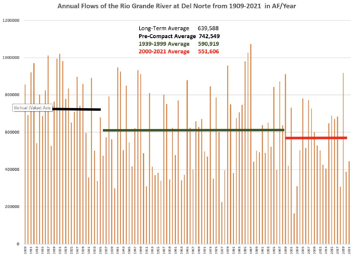
Figure 17. Data sourced from the United States Geological Service.
Rio Grande Compact
The Rio Grande has a complex legal setting that includes two treaties with Mexico, an interstate compact among Texas, New Mexico, and Colorado, and separate compacts on two tributaries, Costilla Creek and the Pecos River. For legal and hydrologic purposes, the Rio Grande can be considered two rivers: the upper river above Fort Quitman, Texas, and the lower river from Ft. Quitman to the Gulf of Mexico. The upper river is a snowmelt driven stream with most of the streamflow originating in the Colorado mountains. On the lower river, most of the runoff originates in Sub-Tropical Mexico. By the 1890s the demand for irrigation water was already exceeding the average supply creating interstate tensions. Hoping to reduce tensions and make the water supply go further, in 1905 the Secretary of the Interior approved the Rio Grande Project which includes Elephant Butte Reservoir. In 1906, the United States agreed to deliver to Mexico 60,000 acre-feet of water from Elephant Butte Reservoir. In return Mexico agreed to waive any further claims to river water above Ft. Quitman. This was the nation’s first international water treaty (referred to as a “Convention”).
In 1929, the three states agreed to a temporary compact or “truce” that would give them time to negotiate a compact. With considerable technical help from the Bureau of Reclamation, the compact was completed and signed on March 18th, 1938. The Rio Grande Compact is a technically detailed compact that requires almost daily diligence and considerable state and local resources to administer. The compact apportions water on an annual basis. Colorado must deliver water to New Mexico based on index gages on the Rio Grande at Del Norte and the Conejos River near Mogote (and gages on two smaller streams, the Los Pinos and San Antonio Rivers). The more water at the index gages, the more Colorado must deliver. The compact also allows for a system of debits and credits. There is currently an active Supreme Court case in which Texas is claiming that groundwater use in New Mexico is a violation of the compact. As a signatory to the compact, Colorado is a party in the case, but Texas is not claiming that Colorado is in violation of the compact. There are press reports that the parties may be close to a negotiated settlement.
In 1944 the United States and Mexico signed a water treaty covering the Lower Rio Grande. The provisions of the treaty do not impact Rio Grande water use in Colorado, but there is an indirect connection. The same 1944 treaty covers the Colorado, Rio Grande, and a third small stream, the Tijuana River. The treaty put in place a geopolitical connection between the Colorado River and the lower Rio Grande. On the Colorado River, all the water that Mexico uses originates within the United States. On the Lower Rio Grande, the opposite is true: most of the water that U.S. farmers on the Lower Rio Grande rely on originates in Mexico.
The Overuse of Groundwater in the Closed Basin
The geohydrology of the Closed Basin, the northern third of the San Luis Valley, is complicated. In its simplified version, there are two aquifers, the unconfined aquifer from the surface down to a confining clay layer, and the confined aquifer which lies below the clay layer. The two aquifers are interconnected because the confining clay layer disappears at the edges of basin near the mountains. Both aquifers are heavily used for irrigation purposes. They are recharged by stream flows from the adjacent mountains, by diversions from the Rio Grande, and by precipitation. Because the wells are shallower, there are many more irrigation wells in the unconfined aquifer. For the last three decades total groundwater withdrawals from the Closed Basin aquifers have exceeded the recharge levels by well over a million acre-feet. To reach sustainable levels of groundwater use, the Rio Grande Basin will have to significantly reduce its current rate of groundwater withdrawals and do it in a way that minimizes the impacts to the region’s agricultural economy. Through the efforts of the Rio Grande Water Conservation District, the basin has set up seven subdistricts for the purpose of managing groundwater withdrawals at a sustainable level as defined by rules and regulations issued by the Colorado Division of Water Resources (State Engineer’s Office). Five of the seven subdistricts have successfully reached this goal, however, Subdistrict No. 1, the largest in both acreage and groundwater withdrawals, has not. To reach sustainability, the irrigators in this subdistrict will have to reduce their pumping by about 90,000 acre-feet per year, about 40% of their recent average withdrawals.
The subdistricts are primarily funded by local taxes and fees supplemented with state and federal (USDA) resources. In 2022, the Colorado legislature made $60 million available to the Rio Grande and Republican River Basins to assist theses basins in reducing groundwater withdrawals through temporary and permanent fallowing programs and other conservation efforts. Basin representatives have suggested reaching sustainability could require another $100-150 million in state assistance.
Figure 18. Map of Rio Grande Groundwater Management Subdistricts. Map courtesy of the Colorado Department of Natural Resources’ Rio Grande Basin Implementation Plan.
The Rio Grande Basin Implementation Plan
The Rio Grande Basin has a very active and engaged basin roundtable that has prepared a detailed and comprehensive basin implementation plan. The goals of the implementation plan are broad: heathy watersheds, sustainable aquifers, a resilient agricultural and valley-wide economy, flexible water rights and compact administration, and an engaged citizenry. The implementation plan bluntly acknowledges the impacts of drought, climate change, and groundwater overuse, proposes a broad range of projects designed to improve diversion system efficiency, improve watershed health, storage improvements, and environmental enhancements. It also includes a detailed discussion of the basin’s groundwater overuse and the subdistrict-based efforts to reduce pumping to sustainable levels. The needs of the Valley’s aquatic environment, its thriving recreation industry, and municipal and industrial uses are included. Under most scenarios, municipal, domestic, and industrial water uses are not expected to grow significantly (in real numbers), but those uses are a part of the appropriation system, and the associated consumptive uses must be prioritized or augmented.
Rio Grande Basin Recommendations
The overuse of groundwater in the Closed Basin has resulted in serious economic damage to the agricultural industry of the San Luis Valley, the region’s primary economic driver. Unfortunately for Colorado, this problem has been too common. Colorado has allowed the overuse of groundwater in the Rio Grande, Arkansas, Republican, and South Platte River Basins. In the Arkansas and Republican Basins, the groundwater uses impact surface flows subject to interstate water compacts. Because the Closed Basin has no natural outlet to the Rio Grande, closed basin groundwater overuse is not a Rio Grande Compact issue. In each of these basins, the burden of reducing the overuse has fallen on agriculture with significant secondary impacts to the local communities and the associated aquatic ecosystems.
- The state’s other basins should consider the lessons learned from the Rio Grande Basin give the local impacts of overusing of the available water supply and the resulting difficulties, perseverance, and financial resources needed to reach sustainability.
- There are many and varied reasons that created the conditions that led to the groundwater overuse, including a climate that was generally wet in the 1980s and 90s, but very dry since 2000, and the local agricultural economics. But as a regulator, the state had a critical role, thus the State of Colorado needs to continue to provide assistance with data, regulatory oversight, and most importantly continued financial resources.
There have been and continue to be proposals to remove groundwater from the Closed Basin and export it to the Colorado Front Range. These efforts have created fierce opposition with the San Luis Valley. The state should consider how to discourage exports out of overused basins such as the San Luis Valley.
Republican River Basin – A Challenge to Economic Survival
The Republican River Basin is located in the far eastern plains of Colorado and flows into Nebraska and Kansas. It was named after a group of Pawnee Indians, that the French explorers called “the Republicans.” Consisting of wild grassland and over 550,000 acres of irrigated lands, the basin covers over 7,000 square miles in Colorado (slightly smaller than New Jersey). Underlying the Basin is part of the High Plains aquifer (also known as the Ogallala aquifer), which spans beneath eight states. Agriculture in this area relies heavily on pumping water from both the High Plains aquifer and alluvial aquifers connected to the Republican River.[l]
Figure 19. Graphic courtesy of Kansas Department of Agriculture.
The High Plains aquifer provides 90% of agriculture’s supply in the Republican River basin, which is a designated basin in Colorado. Control and management of the water supply is controlled by the Colorado Ground Water Commission. Water users must get a permit from the State Engineer to pump from the aquifer. Since the aquifer is not connected to the Republican River, those wells are not affected by the Republican River Compact.[li]
Republican River Compact
After the drought in the 1930’s and a destructive flood in 1935, Colorado, Kansas and Nebraska agreed to discuss how to share the river supplies, which then provided a basis for construction of federal dams in Nebraska and Kansas.
Engineers from the three states studied the river and determined the “virgin” water supply (undisturbed by mankind) of the river within the basin by the major tributaries. The compact then apportioned the river by each tributary. Pursuant to the 1942 Republican River Compact, Colorado is allotted the consumptive use of 54,100 acre-feet with the apportioned flows divided among four subbasins: North Fork of the Republican River, Arikaree River, South Fork of the Republican River and Beaver Creek basins. Colorado is entitled to all the water supply of the Frenchman Creek and the Willow Creek basins. However, if in any given year the computed virgin water supply varies more than 10 percent as established in the Compact, allocations are increased or decreased accordingly. The Compact also established the Republican River Compact Administration, consisting of representatives from each of the three states, to manage the river and collect and correlate data necessary for administration of the Compact.
As agriculture grew in the Republican River basin, more wells withdrew water from alluvial aquifers, which diminished flows in the river. In 2001 Kansas filed a lawsuit against Nebraska and Colorado in the United States Supreme Court and alleged that both states were using more than their compact entitlement to the detriment of Kansas. Nebraska countersued Kansas and Colorado in the same case. Ultimately, the Supreme Court determined that Colorado had not complied with the Compact. The states negotiated an agreement that required Colorado to make retribution to Nebraska and Kansas in the amount of $4 million to each state. As part of a later settlement agreement among the states, Colorado agreed to shut down 25,000 irrigated acres.
In 2004, the Colorado General Assembly established the Republican River Water Conservation District (RRWCD) to provide management of the basin and give local input to assure compliance with the Republican River Compact.
Colorado and RRWCD struggled to assure compliance with the Compact and eventually built a pipeline to deliver groundwater pumped from the High Plains aquifer wells delivered to the Colorado-Nebraska state line. Unfortunately, the project did not provide enough water to meet Colorado’s obligations under the Compact.
Until 2022 the district worked with federal money from the Farm Bill to retire thousands of acres of irrigated farmland to provide adequate flows pursuant to the Compact. The efforts were devastating to some farmers, and unfortunately not enough to achieve full compact compliance. This year in Senate Bill 22-28, the General Assembly appropriated $60 million to assist farmers in the Republican River Basin and the Rio Grande basin. The funds will be used to purchase well permits and retire irrigated acreage. Although more funds are needed to buy and dry farms in order to meet Colorado’s compact obligations, this is a decent start.
Recommendations
State and federal funds should continue to be used to assist Colorado to control water supplies and meet compact obligations.
North Platte Basin: Small but Mighty
Figure 20. Map of the North Platte Basin. Graphic courtesy of the Colorado Department of Natural Resource’s North Platte Basin Implementation Plan.
Covering about 2,000 square miles, the North Platte Basin in north central Colorado is a high-altitude valley, with about 1,400 permanent residents.[lii] The Basin receives an average of 40 inches of precipitation a year. The Basin includes all of Jackson County and a small piece of Larimer County. The major tributaries are the Laramie, Michigan and Canadian Rivers which supply water to irrigate about 113,600 acres. Recreation plays a significant role in the economy of the basin.[liii]
Water in the basin is subject to two U.S. Supreme Court decrees. The 2001 equitable apportionment decree issued in Nebraska v. Wyoming limits the amount of storage supplies and irrigated lands in the basin. The Wyoming v. Colorado decision in 1957 equitably apportioned the Laramie River and limited Colorado’s total diversions and exports from the basin. This case has an interesting history. One of the first transbasin diversions was established in the early 1900’s when water from the Laramie River was transported to the Cache La Poudre River watershed. Wyoming objected, since none of the return flows made it back to the Laramie River and to Wyoming. The original decision in 1922 proclaimed that since both Colorado and Wyoming adopted the doctrine of prior appropriation, the Court would equitably apportion the river, with the senior users in Wyoming having the better right. That decision was a call to action for upstream states that were developing at a slower rate than their downstream partners. The Supreme Court amended the Wyoming v. Colorado decree in 1940 and again in 1957.
The North Platte Basin Implementation plan describes several goals of the basin: maintain compliance with Supreme Court decrees, increase economic development and diversification, restore, maintain and modernize critical water infrastructure, maintain healthy rivers and water sheds, describe nonconsumptive benefits of agricultural use, improve streamflow gaging data, enhance forest health, and support statewide application of municipal water conservation.
Recommendations
- The state resource agencies should support the efforts of the basin in obtaining the goals in the Implementation plan.
- Because the basin is sparsely populated, the State should work with residents to accommodate their representation in water discussions.
Conclusion
It is becoming increasing clear that Coloradans will have to adapt our water systems to do more with less. The combination of impacts from climate change and a growing population are creating growing uncertainty about the future supply and demand of water in Colorado.
Though the legal framework governing water, including statutes, compacts and decrees, presents some barriers, it also provides stability and enough flexibility to make needed changes. Through collaborative action and enhancing the state’s ability to develop water projects at a regional scale, it will be possible to create a sustainable water supply for Colorado to grow and flourish in the 21st century.
Appendices
Appendix A: Intrastate and interstate allocation of Colorado water supplies
Surface Water Allocation in the United States
Surface water allocation in the United States falls into two basic categories: 1) the riparian system and 2) the doctrine of prior appropriation.
The riparian system is common in the Midwest and eastern states. It stems from common law and allows that anyone owning land on a river channel is entitled to reasonably use that water. Non-adjacent landowners do not have a legal right to divert the water. Everyone on the river shares in any shortages.
The doctrine of prior appropriation is used in the West and has its origins in the mining doctrine “first in time, first in right.” To gain a legal right to use of the water, one must put the water to beneficial use. The water can be diverted to land not adjacent to the river. In times of shortage, the earlier use has the better right.
Some states have developed a hybrid system of water allocation by combining elements of both systems. Those states include California, Mississippi, Oregon, and Texas.
Doctrine of Prior Appropriation
The doctrine of prior appropriation, also referred to as the Colorado doctrine, provides users with a sense of certainty in times of shortage. When miners staked their claims in the Colorado Rockies, they used the traditionally held method of resolving disputes: the first to stake a claim has the better right. It was a natural transition to apply that method to the early disputes regarding access to surface water supplies. As early entrepreneurs realized the need to feed and supply the miners, communities and agriculture began to develop and employed the same method for distributing the use of the water. This practice was enacted in the territorial laws of Colorado and then incorporated in Colorado’s state constitution.
Under the Colorado doctrine the state’s surface and groundwater are a public resource and a water right secures a use of the public’s water supply (usufructuary right). Water must be applied to beneficial use with minimal waste. Water right owners may build facilities on the lands of others to divert or move water to its place of use. Streams may be used for the transportation and storage of water. A water right is assigned a priority date when adjudicated by the water court. Water rights are described by point of diversion, beneficial use, and amount (often a flow rate in cubic feet per second or a storage amount in acre-feet). The value of a water right is in its dependability (higher priority, more dependable). The earliest water right in Colorado is the San Luis People’s Ditch in the Rio Grande basin with an 1852 water right for irrigation. Throughout the state, established agricultural rights are the most senior, generally with priority dates in the 1880’s and 1890’s.
Change Of Water Right
A couple of other important concepts under prior appropriation include that a water right can be forfeited by non-use. In Colorado that period is 10 years, and each decade the State Engineer compiles a list of proposed rights that may be abandoned. A water court hearing is required before a right is abandoned. Another concept is the anti-speculation doctrine, which provides that a water user cannot claim more water than can be beneficially used. Thus, a wealthy water user cannot obtain a water right to hoard water supplies for future sale and use. There is a municipal exception to this doctrine, wherein cities that reasonably prove anticipated growth in coming decades may apply for water rights beyond the current need. This is commonly referred to as the “great and growing cities doctrine.”
Interstate Distribution of Water Resources
As the western states began to develop, controversies arose about sharing water in a river flowing through two or more states. In law there are three methods to resolve disputes between states. The first is by a state petitioning the United States Supreme Court to resolve the dispute pursuant to Article III section 2 of the United States Constitution. The Supreme Court has “original jurisdiction” over such disputes and the only court in the nation with the authority to decide such a dispute. Another method is using the compact clause of the U.S. Constitution, Article I section 10, wherein states have the ability to make agreements among themselves usually with approval of Congress. The third method is through United States Congressional action dividing a river among the states. This has happened only once in the Boulder Canyon Project Act (1928) when Congress divided the Lower Basin of the Colorado River between Arizona (2.8 million acre-feet (maf)), California (4.4 maf), and Nevada (0.3 maf).
At the turn of the 20th century, the U.S. Supreme Court heard disputes between Colorado and Kansas on the Arkansas river and Colorado and Wyoming on the Laramie River. In those cases, the Supreme Court indicated that it would apply the doctrine of prior appropriation (the state which puts the water to more beneficial use has the better right). A savvy Colorado water lawyer and rancher from Greeley, Delph Carpenter, expressed his concern to Colorado’s governor and legislators that as a headwaters state, Colorado could be strictly limited in use of water supplies originating in the state if downstream states developed faster than Colorado. Of particular concern was the booming economy in California built on the use of Colorado River water. On behalf of the governor, Carpenter approached the other six basin states and the federal government about an interstate compact agreement. All parties agreed to discussions that led to the 1922 Colorado River Compact. An interstate water compact must be approved by each state’s legislature, signed by each governor, and approved by the United States Congress. Thus, a compact is not only a contractual agreement among the states, but it also is state and federal law.
Colorado is party to nine interstate water compacts and two U.S. Supreme Court decrees. The following chart summarizes each.
Interstate Allocations
Table 3. U.S. Supreme Court Decrees.
| U.S. Supreme Court Decrees | Allocations |
|
Laramie River Decree (1922, 1940, 1957) Wyoming v. Colorado, 259 U.S. 419 (1922); 309 U.S. 572 (1940); 353 U.S. 953 (1957) |
Colorado may divert
|
|
North Platte Decree (1945, 1953, 2001) Nebraska v. Wyoming, 325 U.S. 529 (1945); 507 U.S. 584 (1953); 534 U.S. 40 (2001) |
Colorado may divert
|
Table 4. Interstate Water Compacts.
| Interstate Water Compacts | Allocations |
| Colorado River Compact (1922) |
|
| La Plata River Compact (1922) |
|
| South Platte River Compact (1923) |
|
| Rio Grande Compact (1938) |
|
| Republican River Compact (1942) |
Colorado allocated:
|
| Costilla Creek Compact (1944, amended 1963) |
|
| Upper Colorado River Compact (1948) |
|
| Arkansas River Compact (1949) |
|
| Animas-LaPlata Project Compact (1969) |
|
The climate change driven impacts to water supplies are raising new issues and creating new sources of controversy. Today, there may be less water in Colorado’s River systems than when the interstate compacts were negotiated or the court decrees issued, but the water use limitations and delivery requirements have not changed. In some cases, the amount of water that Colorado can use and benefit from has been dramatically reduced. The impact of climate change on their ability to use water is an issue for all the states that share and use the rivers that have their headwaters in Colorado’s mountains.
The impact of climate change is not the only compact issue facing Colorado. In most cases, interstate water compacts were negotiated to divide the use of the surface stream flow. Disputes over the impacts of groundwater depletions on stream flows covered by compacts has led to interstate litigation on three of Colorado’s major rivers, the Rio Grande, the Arkansas River, and the Republican River. The impacts of the use of hydrologically connected groundwater on surface flows are incredibly complex, difficult to model, and vary considerably from river to river. Water quality is another major concern that can and has led to compact disputes. The presence of native aquatic species protected under the federal Endangered Species Act can be a complicating factor.
In almost all cases, Colorado’s water compacts and court decrees do not expire or have a term limit. By design, they were intended to be permanent and forever agreements. Compacts can be amended, but as a practical matter, substantive amendments are almost impossible. They require the formal approval of each participating state’s legislature and, in most cases, the U.S. Congress. While interstate litigation in front of the United States Supreme Court to resolve disputes over interpretations are common, the Court has never voided or rewritten an interstate water compact.
Appendix B: Glossary
Acre-Foot: Standard unit in water management. Equivalent to roughly 326,000 gallons; commonly visualized as the amount of water needed to cover one football field to the depth of one foot.
Demand Management: Predicting how much future water will be requested by people, companies, and agriculture—among other uses—and making plans to be able to satisfy these demands.
Firming of Supplies: Increasing the reliability of existing water supplies, through the use of storage i.e. removing the risk of water supplies running low in the future.
Interbasin Compact Committee (IBCC): State-level organization in Colorado made up of nine roundtables, each representing a geographic location in the state. Confers on decisions regarding both inter-state and intra-state water management issues.
Interstate Water Compact: Contractual agreements between two or more states, and ratified by Congress, to agreeably divide water for each state’s use. Legal basis provided by the Commerce Clause in the U.S. Constitution.
Urbanization: Changing land cover from agricultural use to home construction.
Water Productivity: Amount of yield per unit of water used.
Appendix C: Selected Regional Projects
Table 5. Selected Regional Projects.
| Project Name | Year Completed | Communities Served | Cost | Volume Added | Cost per AF |
| WISE Project | 2010 | South Metro, Denver Water, Aurora | $638 million | 10,000 AF | $63,800 |
| Windy Gap | 1985 | Northern Colorado | $120 Million | 48,000 AF | $2,500 |
| Chimney Hollow (Windy Gap Firming) |
Ongoing since 2021 | Northern Colorado | $670 million | 30,000 AF | $22,333 |
| Northern Integrated Supply Project (NISP) | Proposed | Northern Colorado | $500 million – $1 billion | 40,000 AF | $12,500 – $25,000 |
Appendix D: Metro Population and Utility Use
Tables 6 and 7 shows the change in Colorado’s population, water usage and water and sewer service costs in 1985 and 2015. The metro counties include Adams, Arapahoe, Boulder, Broomfield, Denver, Jefferson, Douglas, Larimer, Pueblo, and El Paso. The metro counties’ population increased 71.2% while the rest of the counties grew by 63.6%. At the same time, metro counties water usage increased 13.1% while the rest of Colorado counties grew by 19.8%. Water and sewer costs increased 140.6%.
Despite a larger increase in population, metro counties share of total water usage decreased and other counties, with a declining share of total population, increased.
Table 6. Metro population and utility use. Data obtained from the National Association of Clean Water Agencies[liv]
| Colorado Population | ||||||
| 1985 | 2015 | Change 1985 to 2015 | % Change 1985 to 2015 | |||
| Population | Share of Total State Population | Population | Share of Total State Population | |||
| Population Total Metro Counties | 2,478,685 | 77.1% | 4,243,136 | 77.9% | 1,764,451 | 71.2% |
| Rest of Colorado | 735,763 | 22.9% | 1,203,457 | 22.1% | 467,694 | 63.6% |
| Population Colorado | 3,214,448 | 100.0% | 5,446,593 | 100.0% | 2,232,145 | 69.4% |
| Colorado Water Usage per Year and Water & Sewer Service Prices | ||||||
| 1985 | 2015 | Change 1985 to 2015 | % Change 1985 to 2015 | |||
| Usage | Share of Total State Usage | Usage | Share of Total State Usage | |||
| Total Metro Counties | 590,965 | 79.1% | 668,366 | 78.1% | 77,400 | 13.1% |
| Rest of Colorado | 156,352 | 20.9% | 187,306 | 21.9% | 30,954 | 19.8% |
| Colorado | 747,317 | 100.0% | 855,672 | 100.0% | 108,354 | 14.5% |
| Clean Water Index (NACWA) | 101.8 | N/A | 244.9 | N/A | 143.1 | 140.6% |
| Average Annual Sewer Service Charge (NACWA) | $ 104.57 | N/A | $ 251.62 | N/A | $ 147.05 | 140.6% |
Appendix E: Irrigated Acreage
Table 7. Irrigated Acreage per basin. Data courtesy of the 2019 Technical Update to the Colorado Water Plan.
| Basin | Existing Acreage | Projected Urbanized Acreage | % Acreage Lost To Municipal |
| Statewide | 2,670,700 | 152,450 | 5.71% |
| South Platte/Metro | 854,300 | 107,310 | 12.56% |
| Colorado | 206,700 | 13,590 | 6.57% |
| Arkansas | 445,000 | 7,240 | 1.63% |
| North Platte | 113,600 | 40 | 0.04% |
| Rio Grande | 515,300 | 4,010 | 0.78% |
| Southwest | 222,500 | 3,800 | 1.71% |
| Gunnison | 234,400 | 14,600 | 6.23% |
| Yampa-White-Green | 78,900 | 1,860 | 2.36% |
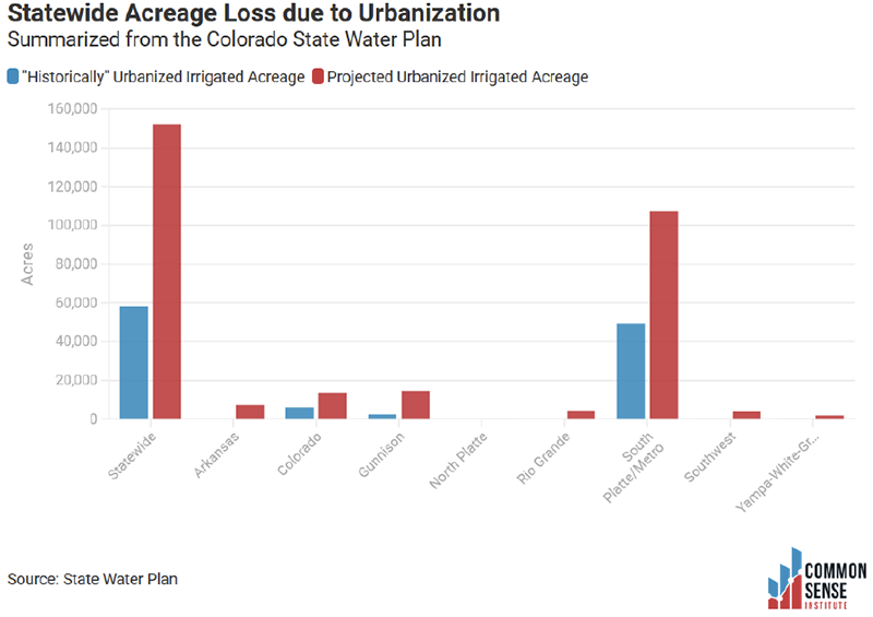
Figure 21. Acreage loss, statewide and per basin. Data courtesy of the 2019 Technical Update to the Colorado Water Plan.
Appendix F: Water Use by Roundtable Basin
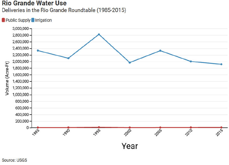
Figure 22. Data sourced from the United States Geological Survey.
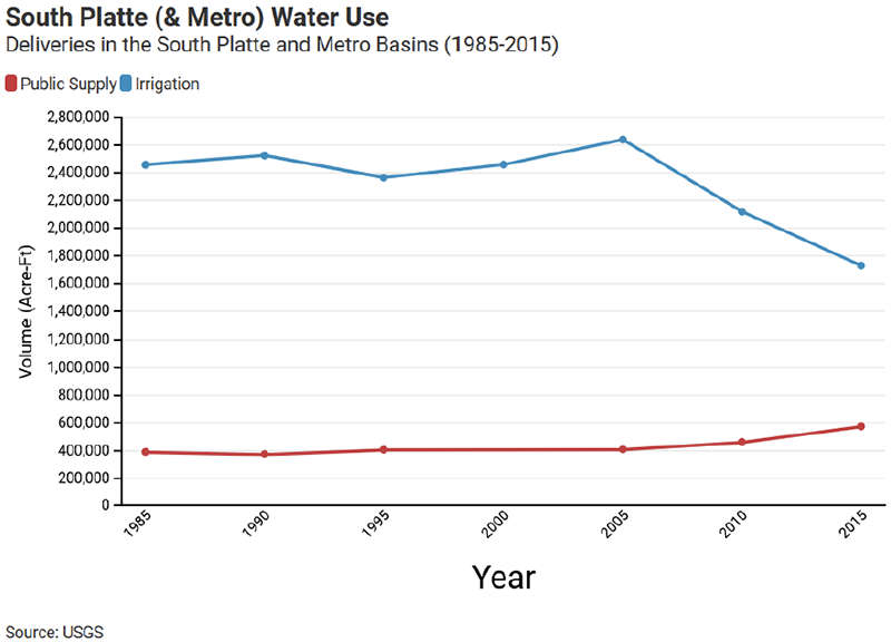
Figure 23. Data sourced from the United States Geological Survey.
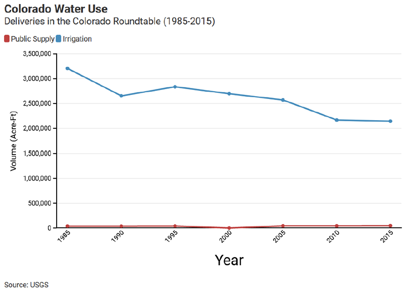
Figure 24. Data sourced from the United States Geological Survey.
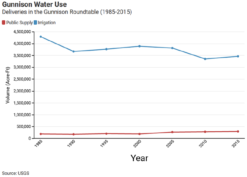
Figure 25. Data sourced from the United States Geological Survey.
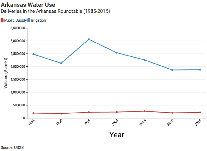
Figure 26. Data sourced from the United States Geological Survey.
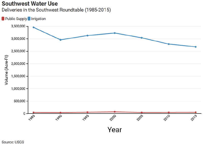
Figure 27. Data sourced from the United States Geological Survey.
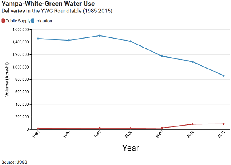
Figure 28. Data sourced from the United States Geological Survey.
Appendix G: Law of the Colorado River
Introduction. The Colorado River is Colorado’s largest surface water supply source. In addition to providing for irrigation, municipal, and industrial uses on the Western Slope, its waters are diverted out of the headwaters into the adjacent Arkansas and South Platte River basins (transbasin diversions). Under the 1922 Colorado River Compact and 1948 Upper Colorado River Basin Compact, post-compact water rights are potentially subject to curtailment, commonly referred to as a “compact call.” A major portion of Colorado’s Colorado River rights are post-compact. They include many rights that are critical to the state’s economy. On the Western Slope these rights include ski area snowmaking uses, municipal uses, thermal power plants and other industrial uses, and reservoirs such as Green Mountain, Taylor Park, McPhee, and Ruedi that provide late season irrigation water and provide augmentation water for numerous other junior rights. All but a handful of the smaller transbasin diversions into the South Platte and Arkansas River basins are post-compact. Many of the major cities on the Front Range are reliant on post-compact Colorado River water rights. About 65% of Colorado Springs’ water supply is obtained from the Colorado River. It makes up about 50% of Denver’s supply, and 25% of Aurora’s. Additionally, the Colorado-Big Thompson Project and its non-federal companion, the Windy Gap Project, deliver Colorado River water to many Northern Front Range cities from Broomfield to Ft. Collins.
The threat that Colorado’s post-compact Colorado water rights might have to be curtailed is not new. The Upper Basin compact commissioners and their advisors spent considerable time discussing and negotiating how such a curtailment would be administered. Article IV was included in the 1948 Upper Basin Compact to provide procedures for a curtailment. Making the critical decisions necessary for a curtailment is the primary reason the 1948 Compact created a permanent Upper Colorado River Compact Commission. Until recently, however, the threat of a curtailment was considered very remote and many decades away. Therefore, there was little concern that in the future water from post-compact water rights would not be available. Furthermore, there was a general understanding that as individual states approached “full” development, they would carefully manage their development levels to avoid any serious risk of a curtailment.[1] As late as 2005, there was a general belief that the Upper Basin States could collectively consume up to about six million acre-feet per year without any serious threat of not meeting their collective 1922 compact obligations at Lee Ferry.[2]
What was not anticipated was how quickly and dramatically climate change has impacted the natural flow of the Upper Colorado River Basin above Lee Ferry. During the 20th century, the estimated long-term natural flow at Lee Ferry was about 15 million-acre feet per year. Since 2000, the estimated natural flow has only been about 12.2 million acre-feet per year, nearly a 20% decline. Further, climate scientists are now concluding that due to aridification, the flow declines should be considered the “new abnormal” and will continue for decades into the future. The combination of climate change driven flow declines and the Upper Basin’s 1922 Compact obligations at Lee Ferry substantially raises the risk that a curtailment may be necessary, either by a decision of the Upper Colorado River Compact Commission or, more likely, a court decision. The increased risk of a curtailment raises fundamental policy questions for the entire basin and brings to the forefront many unresolved disputes concerning the interpretation of the 1922 Compact, the 1948 Upper Basin Compact, and other provisions of the Law of the River.[3]

Figure 29. Map courtesy from the USBR 2012 Colorado River Basin Study.
The 1922 Compact
November 24th, 2022 will mark the 100th anniversary of the signing of the Colorado River Compact. The compact is considered the cornerstone of the Law of the River. What brought the compact commissioners together in 1922 was a clear need to divide the use of the river’s water among the seven states in an equitable manner so that development of the river could proceed without political conflict and litigation. At the time, the lower river, especially California, was developing much faster than the upper river. The upper states feared that if the concept of prior appropriation was applied on an interstate basis, the large reservoirs and diversion systems already in place or being proposed would command the entire river precluding future development in the upper states when they would ultimately need more water.
In 1920 Colorado attorney Delph Carpenter, now considered the father of interstate water compacts, proposed the basin states negotiate a compact that would divide the use of the water, settle their differences, open the door for the federal legislation that would be needed to develop the river. The compact idea was endorsed by all seven basin states. The Colorado River Commission first met in Washington D.C. in January 1922. Secretary of Commerce Herbert Hoover, appointed by President Harding to be the federal representative, was elected chairman. The commission’s original goal was to apportion the use of the water among the seven states. The commission quickly reached a stalemate trying to accomplish a seven-way division. Instead, building on a recommendation made by Arthur Powell Davis, Director of the Reclamation Service (now the Bureau of Reclamation), the commission decided to divide the use of the water among two geographic sub-basins, an Upper Basin, and a Lower Basin. The dividing point was defined as Lee Ferry, a point on the river in Northern Arizona, just before the river begins its long journey through the Marble and Grand Canyons. Note that there is a difference between the compact definitions for the “Upper Basin” which is the drainage area above Lee Ferry and the “States of the Upper Division”, which are Colorado, New Mexico, Utah, and Wyoming. The Lower Basin is the drainage area below Lee Ferry and the States of the Lower Division which are Arizona, California, and Nevada.
Pictured: Delph Carpenter
In November 1922, when the commission finally reconvened, the representatives accepted Carpenter’s suggestion of dividing the basin into the Upper and Lower Basins and appropriating the flows equally between them. Under Articles I, III(a), and III(b) the compact divided the water into four parts, 7.5 million acre-feet for the Lower Basin,[4] 7.5 million acre-feet for the Upper Basin, an additional 1 million acre-feet to the Lower Basin from tributaries in that basin, and a fourth “surplus” pool that would be set aside for Mexico and for further apportionment to each basin after October 1st, 1963.
- Believing that the river’s total water supply at the mouth of the river (which includes the Gila River system) was at least 20.5 million acre-feet (about 17.5-18 million acre-feet at Lee Ferry), the commissioners thought that this “surplus” pool would be 4.5 to 5.0 million acre-feet. We now understand that the river’s long-term total water supply was far less than 20.5 million acre-feet per year. The 20th-century average is about 16 million acre-feet per year, since 2000 it is about 13 million acre-feet per year. By the 1950s, it was recognized that if there was a surplus pool, it was small and, today, the basin may be overallocated by 4 to 4.5 million acre-feet.
- Article III(c) requires the States of the Upper Division to “not cause” the flow of the river to be depleted below 75 million acre-feet every ten consecutive years. Representatives of the Upper Division States are quick to point out that this is a “non-depletion” obligation NOT a “delivery” obligation.
- Under Article III(c), water for Mexico under a future treaty would first be provided from the 4.5 to 5.0 million acre-feet surplus pool. If this surplus pool was insufficient, there are different legal theories about how much each basin must contribute to meet the obligations of the Treaty. Under Article IV, the use of water for power generation is subordinated to the use of water for domestic (broad definition) and irrigation purposes. The compact also includes a provision that the compact not interfere with the obligations of the United States to Indian tribes (Article VII) and a provision to not impair water rights perfected before the compact was signed or approved (Article VIII), referred to as “present perfected rights”. This is an important provision. Water rights protected by Article VIII are now referred to as “pre-compact” rights. Those not protected, and thus are subject to a curtailment, are referred to as “post-compact” rights. Unfortunately, there are differences of opinion on how to apply this provision under the compact.[5]
The Boulder Canyon Project Act. After the compact was signed by the commissioners, the four Upper Division States and Nevada quickly ratified the compact, then things got messy. Arizona’s legislature refused to ratify the compact and California initially conditioned its ratification on approval of the Boulder Canyon Project. Approval of the compact became in doubt. The approval issue was partially resolved in December 1928 when Congress passed the Boulder Canyon Project. The 1928 Act authorized the construction of Boulder Dam and the All-American Canal[6] and provided a conditional approval of the 1922 Compact if either all seven states ratified the compact or if six states ratified it, including California, and that California agreed to limit its use to 4.4 million acre-feet of III(a) water plus one half of the unapportioned surplus. The 1928 Act allocated Lower Basin supplies in the following ways: California with 4.4 million acre-feet, Arizona with 2.8 million acre-feet, and Nevada with 300,000 acre-feet.
The Boulder Canyon Project became effective on June 25th, 1929. Construction of Boulder Canyon Dam (now Hoover Dam) and the All-American Canal began in the early 1930s. Hoover Dam was officially completed in March 1936. By 1941 Lake Mead was full and the All-American Canal was delivering water to the Imperial Dam. The rapid development of Hoover Dam, the All-American Canal, and the Colorado River Aqueduct, which delivers water from Lake Havasu to Los Angeles and San Diego proved Carpenter’s concerns correct. Without a compact to protect the Upper Basin, these large projects could have commanded the entire river in many years.
After three failed attempts to litigate compact issues in front of the Supreme Court in the 1930s, Arizona finally ratified the 1922 Compact in 1944 shortly before the United States and Mexico completed negotiating the water treaty between the two countries.
The 1944 Treaty with Mexico. Negotiations for an international treaty between Mexico and the United States covering the use of the Colorado River and the Lower Rio Grande began in the late 1920s then quickly stalled.[7] The negotiations were reinitiated in 1937 and were completed in 1944. The treaty which was ratified by the Senate in 1945 provides Mexico with a normal year delivery of 1.5 million acre-feet per year. It also includes provisions for delivering an additional 200,000 acre-feet during surplus years and reducing deliveries during “extraordinary drought” years, a term which is not defined in the treaty.
The treaty ratification divided the Colorado River water community. The four Upper Division States and Arizona supported ratification. California and Nevada opposed it. Within individual states, some water users supported the treaty, others opposed it. Colorado played a pivotal role in gaining Senate approval of the treaty. Then CWCB Director Clifford Stone, his lead attorney Jene Breitenstein, and his principal engineer Royce Tipton, were all key witnesses for Senate approval.
The 1948 Upper Colorado River Basin Compact. The four States of the Upper Division and Arizona, which has a small amount of land in the Upper Basin, began negotiating the Upper Basin Compact in 1946. After numerous meetings of the commission and its engineering and legal subcommittees, the compact was signed on October 11th, 1948. The primary purposes of the Upper Basin compact are to apportion to the individual states, the use of the waters available to the Upper Basin under the 1922 Compact and to define the obligations of each Upper Division State for delivery of water to Lee Ferry, and if necessary to comply with the 1922 Compact. The 1948 Compact also includes provisions dealing with the waters of several tributaries that are shared between two states, like the Little Snake River which crisscrosses the Wyoming -Colorado border. It also created the Upper Colorado Compact Commission, made up of one commissioner from each Upper Division State and one from the United States to administer the compact.
By the late 1940s, it was well understood that there was less water available than the assumptions made by the 1922 Compact Commission. The Upper Basin Engineering Committee concluded that the long-term natural flow at Lee ferry was about 15.6 million acre-feet per year, less than the assumed 17.5 million acre-feet, but still far more than post-2000 average of 12.2 million acre-feet. So, to be conservative, the Upper Basin Commission decided to apportion water by percentage, not a fixed amount. The exception was Arizona, which received a small, fixed apportionment of 50,000 acre-feet per year. Colorado received the largest apportionment – 51.75% of the water available for use in the Upper Basin. Article IV of the Upper Basin Compact prescribes how the Upper Colorado River Commission (UCRC) determines the amount of water each Upper Division would have to deliver to Lee Ferry if the UCRC determines that a curtailment is necessary to be in “full compliance” with the 1922 Compact. Article IV includes what is referred to as a “ten-year penalty box” provision. If a curtailment is necessary and the UCRC determines that one or more states has used more than its (or their) apportionment over the last ten years, then the overuse must be delivered to Lee Ferry before the other states (with no overuse) have any obligation to deliver water to Lee Ferry. Once that determination is made, each state must deliver to Lee Ferry. It is up to each state to administer a curtailment within that state. The UCRC has no role in intra-state water administration.
The 1956 Upper Basin Storage Project Act. The 1948 Upper Basin Compact set the stage for Congressional approval of the Colorado River Storage Project Act in 1956. CRSPA authorized the construction of Glen Canyon Dam, Flaming Gorge Dam, the Aspinall Unit, and many other “participating projects” throughout the Upper Basin. By necessity, the 1948 Compact is much more detailed and administratively complex than the 1922 Compact. Several important observations:
The 1963 Arizona v. California Supreme Court Decision. The states with Lower Basin interests (which includes New Mexico and Utah which have lands in the Lower Basin) could never agree on a Lower Basin compact. Instead, they turned to litigation. In 1952 Arizona sued California in the Supreme Court. The case was finally decided in 1963. In its landmark decision, the court ruled that the 1928 Boulder Canyon Project Act was a congressional apportionment of the Lower Basin mainstem water, but not the Lower Basin tributaries. The court avoided any interpretation of the 1922 Compact. Colorado and Wyoming, with no Lower Basin interests, were not parties in the case.[8] Important to today’s problems on the river, the court decision made (or confirmed) the secretary of the interior as the Water Master for the Lower Basin mainstem. The decision also adjudicated the rights of Indian tribes on the mainstem and confirmed their senior pre-compact status.
The 1968 Colorado River Basin Projects Act. The Supreme Court’s 1963 decision cleared the way for the Congressional authorization of the Central Arizona Project which it did in 1968 with the Colorado River Basin Projects Act. The 1968 Act did several other things, including authorizing more Upper Basin projects (some were never built) and directing the secretary to prepare long-range operating criteria for coordinated operation of Lake Mead, Lake Powell, and the other CRSP storage reservoirs. Long-Range Operating Criteria were approved by the secretary in 1970.
Other Provisions. The 1922 and 1948 Compacts, the 1944 Treaty, the 1963 Supreme Court decision, and the three major federal development acts might be considered the basic blocks of the Law of the River, but they are not the only elements. They are supplemented by other federal and states laws, examples are the 1928 California Limitation Act and the 1992 Grand Canyon Protection Act. The law also includes secretarial decisions and agreements such as the 2007 Colorado River Interim Guidelines for Lower Basin Shortages and the Coordinated Operations for Lake Powell and Lake Mead (2007 Interim Guidelines) and the 2019 Drought Contingency Plans which expire in 2026 and are currently being renegotiated.
Appendix H: Population Graphs
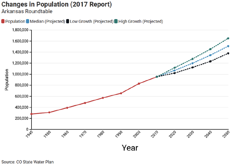
Figure 31. Data sourced from Colorado State Water Plan 2017 Report
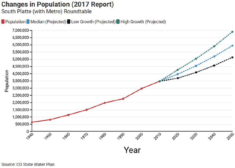
Figure 32. Data sourced from Colorado State Water Plan 2017 Report
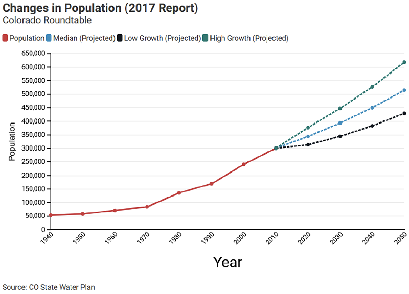
Figure 33. Data sourced from Colorado State Water Plan 2017 Report
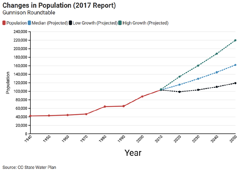
Figure 34. Data sourced from Colorado State Water Plan 2017 Report
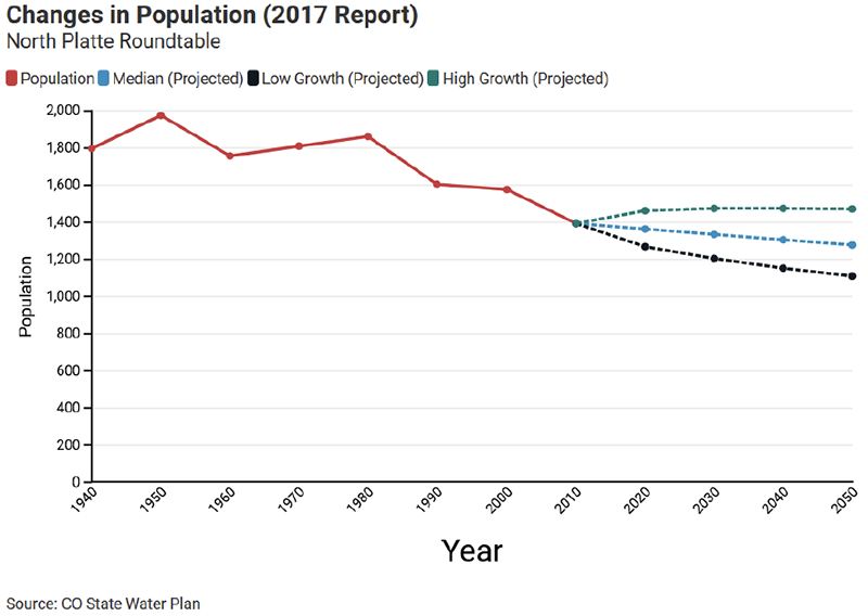
Figure 35. Data sourced from Colorado State Water Plan 2017 Report
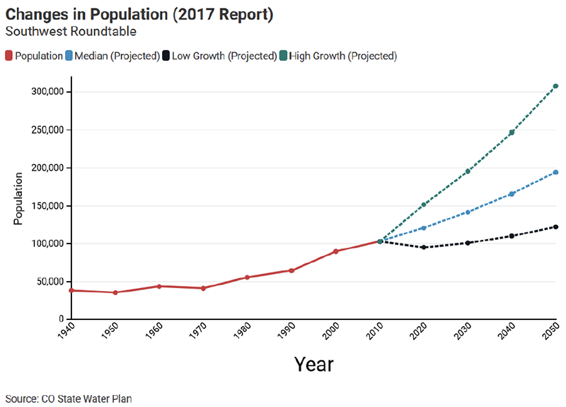
Figure 36. Data sourced from Colorado State Water Plan 2017 Report
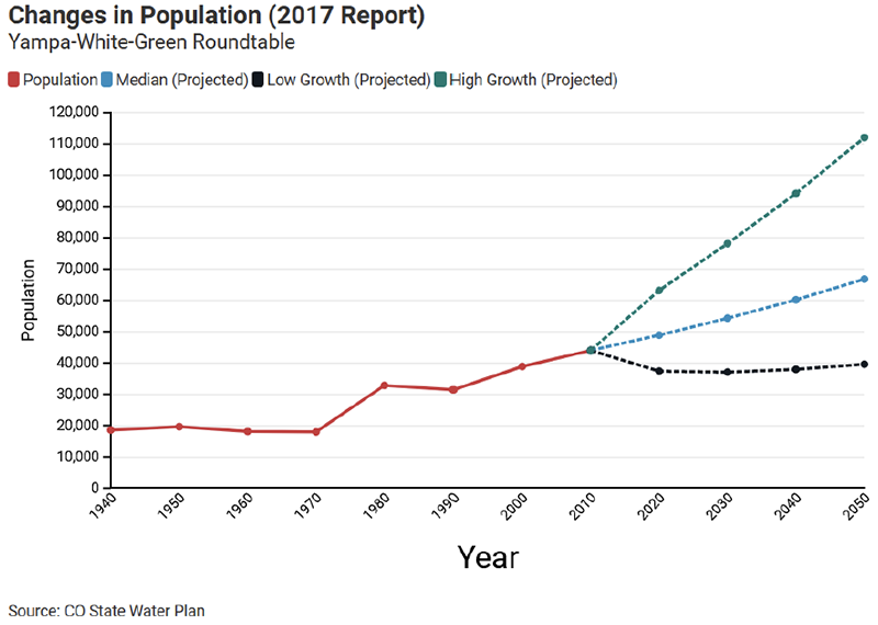
Figure 37. Data sourced from Colorado State Water Plan 2017 Report
Appendix I: Recent Trends in Water and Sewer Prices
The National Association of Clean Water Agencies tracks the cost of clean water for all ten of the EPA regions, see Figure 8. Colorado is in region 8 along with Montana, North Dakota, South Dakota, Utah, and Wyoming.
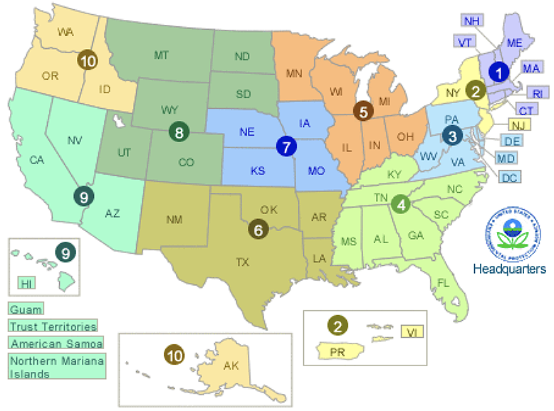
Figure 38. Graphic sourced from the National Association of Clean Water Agencies.
Figure 39 shows the average annual service charge for clean water since 1985 for all ten EPA regions. Since 2005, region 8, the mountain region has had the lowest average annual service charge for clean water among the 10 regions. A comparison of each region’s average annual service charge relative to region 8 shows region 1 is 212% higher, region 2 (63%), region 3 (114%), region 4 (87%), region 5 (64%) region 6 (41%), region 7 (102%), region 9 (53%), and region 10 (132%).
Figure 39. Graphic sourced from the National Association of Clean Water Agencies.
Figure 40 shows the average annual sewer service charge for each EPA region since 1985. Since 1997, region 8 has had the lowest annual sewer service charge.
Figure 40. Graphic sourced from the National Association of Clean Water Agencies.
Appendix J: Dedicated Water for Housing Model Methodology and Raw Results
The following appendix explains the methodology of the dedicated water housing model, along with displaying raw results of selected input scenarios.
Assumptions made:
- Single-family and multi-family lots were the two lot sizes considered.
- Every single-family lot had one dedicated water value applied to represent the unit type. Every multi-family lot had one dedicated water value assumed to represent the unit type.
- Water demand would be uniformly reduced by a set amount per year, if applicable.
- When classifying results per basin, counties that spanned multiple basins were assigned a single most representative basin; in other words, counties were not split between basins, nor duplicated in more than one basin.
- Price ranges for water were held constant over the course of a decade.
The following table lists the inputs for the model, considering both supply considerations and potential reductions in demand over the decade:
Table 8. Inputs for housing water model.
| Dedicated Water Volume | |
| Single-Family | Multi-Family |
| Yearly Acre-Ft Reduction in Dedicated Water | |
| Single-Family | Multi-Family |
| Price per Acre-Ft | |
| High Price Estimate | Low Price Estimate |
| Unit Share ‘What If’ | |
| Single-Family Ratio | Multi-Family Ratio |
Results in acre-ft and dollars were classified by statewide, countywide, and basin-wide summaries. Scenarios included single-family only, multi-family only, historical ratios between single-family and multi-family units, and ‘What If’ ratios between single-family and multi-family units, the last of which relates to the final model input. This ‘What If’ ratio has been set at half Single-Family, and half Multi-Family.
Scenario: (Baseline)
Input Assumptions:

Results:
Scenario (0.01 AF yearly demand reduction):
Assuming:

Results:
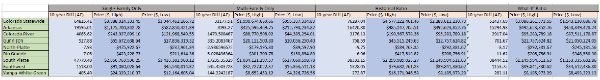
Appendix K: Economic Impacts per Basin
The following tables summarize the economic impacts by 2050 of not closing the projected supply gaps in the 2017 Colorado State Water Plan. The full analysis can be found in Volume 2, Section 9 of 2019 technical updated documentation.[lv]
Arkansas Basin
| Reduced Economic Output | $2.5 billion to $7.5 billion |
| Reduced Gross Regional Product | $1.3 billion to $4.2 billion |
| Reduced Employment | 22,500 to 60,400 jobs |
| Reduced Labor Compensation | $0.9 to $2.9 billion |
| Reduced State and Local Tax Revenues | $143 to $511 million |
| Reduced Consumer Welfare | $258 to $442 million |
Colorado Basin
| Reduced Economic Output | $3.0 billion to $4.9 billion |
| Reduced Gross Regional Product | $1.7 billion to $4.2 billion |
| Reduced Employment | 22,500 to 39,000 jobs |
| Reduced Labor Compensation | $1.2 to $1.9 billion |
| Reduced State and Local Tax Revenues | $212 to $354 million |
| Reduced Consumer Welfare | $99 to $170 million |
Gunnison Basin
| Reduced Economic Output | $122 to $395 million |
| Reduced Gross Regional Product | $52 to $184 million |
| Reduced Employment | 1,800 to 4,000 jobs |
| Reduced Labor Compensation | $41 to $118 million |
| Reduced State and Local Tax Revenues | $4 to $31 million |
| Reduced Consumer Welfare | $26 to $45 million |
North Platte Basin
| Reduced Economic Output | $32 million |
| Reduced Gross Regional Product | $9 million |
| Reduced Employment | 170 jobs |
| Reduced Labor Compensation | $9 million |
| Reduced State and Local Tax Revenues | $0.8 million |
| Reduced Consumer Welfare | $0.5 million |
Rio Grande Basin
| Reduced Economic Output | $298 to $396 million |
| Reduced Gross Regional Product | $135 to $185 million |
| Reduced Employment | 2,400 to 3,400 jobs |
| Reduced Labor Compensation | $95 to $127 million |
| Reduced State and Local Tax Revenues | $9 to $21 million |
| Reduced Consumer Welfare | $18 to $31 million |
South Platte/Metro Basin
| Reduced Economic Output | $43 to $72 million |
| Reduced Gross Regional Product | $25 to $41 million |
| Reduced Employment | 273,000 to 442,000 jobs |
| Reduced Labor Compensation | $16 to $27 billion |
| Reduced State and Local Tax Revenues | $2.7 to $4.7 billion |
| Reduced Consumer Welfare | $0.7 to $1.3 billion |
Southwest Basin
| Reduced Economic Output | $1.7 to $2.4 billion |
| Reduced Gross Regional Product | $0.9 to $1.2 billion |
| Reduced Employment | 14,000 to 20,000 jobs |
| Reduced Labor Compensation | $548 to $787 billion |
| Reduced State and Local Tax Revenues | $133 to $196 billion |
| Reduced Consumer Welfare | $32 to $55 billion |
Yampa-White Basin
| Reduced Economic Output | $2.4 to $2.8 billion |
| Reduced Gross Regional Product | $1.3 to $1.5 billion |
| Reduced Employment | 15,000 to 18,000 jobs |
| Reduced Labor Compensation | $682 to $799 million |
| Reduced State and Local Tax Revenues | $162 to $191 million |
| Reduced Consumer Welfare | $59 to $100 million |
Appendix L: Recommended readings
- Colorado Water Conservation Board, Colorado Water Plan, 2023, 2022 Draft. Colorado Water Plan | DNR CWCB
- Colorado Water Conservation Board, 2019 Technical Update to the 2023 Colorado Water Plan. Technical Update to the Water Plan | DNR CWCB (colorado.gov)
- Colorado Water Conservation Board, Colorado Water Plan 2015, https://dnrweblink.state.co.us/CWCB/0/edoc/199531/FinalCombinedCWPJune2016.pdf
- Colorado Water Conservation Board, Basin Implementation Plans, nine total, one for each basin roundtable, Basin Implementation Plans | DNR CWCB (colorado.gov)
- Colorado Energy Office, Colorado Climate Change Vulnerability Study, January, 2015, Newsletter 4 (state.co.us)
- Colorado Water Conservation Board, Climate Change in Colorado, A synthesis to Support Water Resources Management and Adaptation, 2008, CIRES-Climate Change (state.co.us)
- Water Research Foundation, Joint Front Range Climate Change Vulnerability Study, 2012, Joint Front Range Climate Vulnerability Study (state.co.us)
- Water Education Colorado, Citizen’s Guide to Colorado’s Interstate Water Compacts, Citizen’s Guide to Colorado’s Interstate Water Compacts – Water Education Colorado
- Water Education Colorado, Headwaters Magazine, Spring 2019, “What Will a Hotter Future Mean for Water?” Spring 2019: What Will a Hotter Future Mean for Water? – Water Education Colorado
- Colorado Water Center, Colorado Water, June 2021, Climate Change and Adaptation, Colorado Water Archive | Colorado Water Center | Colorado State University (colostate.edu)
[1] Beginning in the 1950s, Colorado and its sister Upper Division States routinely sponsored or conducted studies to determine the Upper Basin’s “safe yield.” The first of such studies was the Leeds-Hill Report in the 1950s.
[2] The latest Hydrologic Determination was completed and submitted to Congress in 2005. It concluded that the Upper Basin could reasonably develop about six million acre-feet per year based on an average natural flow of 15 million acre-feet per year at Lee Ferry.
[3] Under Carpenter’s compact each basin could develop 8.7 million acre-feet which is one half of the 17.4 million acre-feet of flow at Yuma. There were some basic hydrologic flaws with his proposal.
[4] The Lower Basin received an apportionment of 7.5 maf under article III(a) plus an additional 1.0 maf under Article III(b). for a total of 8.5 maf. There are now different views on the purpose of the III(b) water, but based on their compact reports, Carpenter, Hoover, and the other commissioners made no distinction between the III(a) and III(b) water.
[5] In the 1963 Arizona v. California decision, the court interpreted “present perfected rights” as it used in the Boulder Canyon Project Act, but the court was specifically not interpreting the compact.
[6] The All-American Canal was built to replace the original Alamo Canal which began delivering water to the Imperial Valley in June 1901. The Alamo Canal used a gravity route that went through Mexico. To obtain approval from Mexico the California Development Company, the private predecessor to the Imperial Valley Irrigation District, had to give farmers in Mexico 50% of the water diverted. The CDC went bankrupt in 1906 fighting the flood that created the present Salton Sea. IID was created in 1911 by the Imperial Valley farmers to buy the water delivery system from the Southern Pacific Railroad which spent a lot of money putting the Colorado River back on a course to the sea and took possession of the water system after the bankruptcy. Immediately after it was formed IID began lobbying Congress for an All-American Canal that would not go through Mexico and a large dam on the Colorado River to control the Colorado River and prevent flooding of the valley which mostly lies below sea level.
[7] The 1944 Treaty also addressed the Tijuana River, a small stream that runs from the mountains east of San Diego to the Pacific Ocean near Tijuana, Mexico.
[8] Early in the Case, California asked the court to bring Colorado and Wyoming into the case. Colorado, Wyoming and the other non-California states opposed this motion and the court agreed with them. Colorado’s primary concern was that participating in the case might have delayed Congressional action on CRSPA.
[i] https://choosecolorado.com/key-industries/outdoor-recreation/
[ii] https://waterknowledge.colostate.edu/water-management-administration/water-uses/
[iii] [Draft CWP p3-7].
[iv] [https://waterknowledge.colostate.edu/water-management-administration/water-uses/].
[v] [Colorado Water Plan Fact Sheet https://dnrweblink.state.co.us/CWCB/0/edoc/217378/2023WaterPlanRolloutOnePagerFINAL.pdf] or draft CWP p. 3-4]
[vi] https://waterknowledge.colostate.edu/water-management-administration/water-uses/
[vii] Draft CWP 3-3
[viii] https://dnrweblink.state.co.us/CWCB/0/edoc/217373/ColoradoWaterPlanPublicReviewDraft.pdf
[ix] https://csfs.colostate.edu/colorados-forests-changing-climate/
[x] https://statesummaries.ncics.org/chapter/co/
[xi] https://www.crwua.org/assets/downloads/2021-annual-conference/Udall-Presentation-2021.pdf
[xii] https://www.pnas.org/doi/10.1073/pnas.2006323117
[xiii] https://www.denverwater.org/tap/legacy-colorados-largest-wildfire
[xiv] Hurdle, John, YaleEnveironment360,” As Climate Fears Mount, some in the U.S. Decide to Relocate. March 24, 2022.
[xv] https://e360.yale.edu/features/as-climate-fears-mount-some-in-u.s.-are-deciding-to-relocate#:~:text=Another%20projection%2C%20by%20Matthew%20Hauer,nearly%20six%20feet%20%E2%80%94%20by%20then.
[xvi] 2019 Technical Report p 45
[xvii] Meeting Colorado’s Future Water Supply Needs Opportunities and Challenges Associated With Potential Agricultural Water Conservation Measures Kelly DiNatale Todd Doherty Reagan Waskom Rick Brown September 2008 Special Report No. 20, Colorado Water Institute
[xviii] Windy Gap Bypass Project Aims to Reconnect the Colorado River (alloutdoor.com)
[xix] Colorado Water Plan, cwcb.colorado.gov/colorado-water-plan
[xx] https://cwcb.colorado.gov/colorado-water-plan/technical-update-to-the-plan
[xxi] https://cwcb.colorado.gov/colorado-water-plan/basin-implementation-plans
[xxii] https://developmentwater.com/
[xxiii] https://www.watereducationcolorado.org/fresh-water-news/front-range-farmers-look-to-cities-to-lease-water-as-prices-surge/
[xxiv]Miller, O. L., Miller, M. P., Longley, P. C., Alder, J. R., Bearup, L. A., Pruitt, T., Jones, D. K., Putman, A. L., Rumsey, C. A., & McKinney, T. (2021). How will baseflow respond to climate change in the upper colorado river basin? Geophysical Research Letters, 48(22). https://doi.org/10.1029/2021gl095085
[xxv] https://new.azwater.gov/news/articles/2022-22-07
[xxvi] POTENTIAL IMPACTS OF CLIMATE CHANGE ON INFRASTRUCTURE IN THE PLATTE RIVER BASIN MAY 2015
Homeland Security,Infrasturcture Risk Assessment, https://www.waterisac.org/system/files/articles/OCIA%20-%20Potential%20Impacts%20of%20Climate%20Change%20on%20Infrastructure%20in%20the%20Platte%20River%20Basin.pdf
[xxvii] https://www.denvergov.org/Government/Agencies-Departments-Offices/Agencies-Departments-Offices-Directory/Department-of-Transportation-and-Infrastructure/Programs-Services/One-Water
[xxviii] https://www.watereducationcolorado.org/fresh-water-news/two-new-colorado-river-reservoirs-are-rising-on-the-front-range-are-they-the-last-of-their-kind/#:~:text=In%202021%20Denver%20Water%20diverted,causes%20more%20significant%20storm%20activity.
[xxix] https://www.northernwater.org/what-we-do/deliver-water/colorado-big-thompson-project
[xxx] https://www.northernwater.org/what-we-do/deliver-water/windy-gap-project; https://www.denverwater.org/grossreservoir#:~:text=Construction%20is%20underway,feet%20to%20119%2C000%20acre%2Dfeet.
[xxxi] draft report p 4-47
[xxxii] 2007 Census of Agriculture, USDA
[xxxiii] https://dnrweblink.state.co.us/CWCB/0/edoc/212963/ATM%20Status%20Report.pdf
[xxxiv] https://platteriverprogram.org/
[xxxv] technical update p44
[xxxvi] Memorandum of Understanding by and among Colorado River Basin Municipal and Public Water Providers August 24, 2022, https://www.denverwater.org/sites/default/files/water-efficiency-mou.pdf
[xxxvii] https://www.douglas.co.us/planning/water-resources/
[xxxviii] https://southmetrowater.org/our-work/supply-infrastructure
[xxxix]SPROWG Feasibility Study Report, March 6, 2020, https://www.southplattebasin.com/documents/sprowg
[xl] spwcd.org/index_files/Page1677.htm
[xli] https://www.northernwater.org/what-we-do/deliver-water/canals-pipelines-and-outlets/southern-water-supply-project#:~:text=The%20Southern%20Water%20Supply%20Project,the%20pipeline%20began%20in%201991.
[xlii] https://www.northernwater.org/nisp
[xliii] https://chatfieldreallocation.org/
[xliv] https://greeleygov.com/services/ws/trp/greeley’s-water-future
[xlv] USGS gage record for the Arkansas River at Nathrop, Pueblo, and Granada https://waterdata.usgs.gov/nwis/rt
[xlvi] ColoradoWaterPlanPublicReviewDraft (3).pdf Chapter 3
[xlvii] McCoy, Tom, ”Rocky Prod Ditch Sale Prime Example of State’s Water Law,” September 15, 2004.
[xlviii] https://www.auroragov.org/residents/water/water_system#:~:text=Water%20Sources,-The%20city%27s%20water&text=Our%20surface%20water%20originates%20in,the%20Arkansas%20(25%20percent).
[xlix] Blythe and Schmidt, Water Resources Research, Estimating the Natural Flow Regime of Rivers with Long-Standing Development: The Northern Branch of the Rio Grande, February 2013
[l] http://republicanriver.org/the-states/state-of-colorado/
[li] Technical Update (2019) p 41
[lii] North Platte Basin Implementation Plan p 6
[liii] North Platte Basin Implementation Plan https://cwcb.colorado.gov/colorado-water-plan/basin-implementation-plans#
[liv] https://www.nacwa.org/
[lv] https://dnrftp.state.co.us/#/CWCB/Technical%20Update%20to%20Water%20Plan/1.%20Technical%20Update%20Documentation/